
Citadel of the Hồ Dynasty
| UNESCO World Heritage Site | |
|---|---|
 | |
| Criteria | Cultural: ii, iv |
| Reference | 1358 |
| Inscription | 2011 (35 Session) |
Citadel of Hồ Dynasty (Vietnamese: Thành nhà Hồ; also called Tây Đô castle or Tây Giai castle) is a citadel in Vietnam, constructed by the Hồ Dynasty (1400-1407).
It is located in Tây Giai commune, Vĩnh Lộc district, in Thanh Hóa Province, in Vietnam's North Central Coast region. Its coordinates at 20°4′40″N 105°36′17″E / 20.07778°N 105.60472°E.
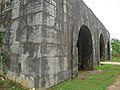
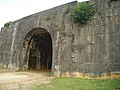
Tây Đô castle is rectangular in shape. Its north-south side is 870.5 m (2,856 ft) in length and its east-west side is 883.5 m (2,899 ft) in length. There are four gates: one at the south (fore gate), one at the north (back gate), one at the east (left gate), and one at the west (right gate). The southern gate is 9.5 m (31 ft) high and 15.17 m (49.8 ft) wide.
The castle was constructed from stone blocks, each of which is Template:Convert/3 size on average.
Except for its gates, the castle is mostly ruined.
The Citadel was inscribed on UNESCO World Heritage Sites on June 27, 2011.[1]
Gallery
-
 South gate
 -
 North gate
 -
 East gate
 -
 A stone cannon ball found in Tây Đô castle


References and external links
- Hồ castle (in Vietnamese)
References
This Vietnam-related article is a stub. You can help Wikipedia by expanding it. |