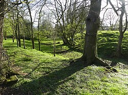
Dodleston Castle
Appearance
| Dodleston Castle | |
|---|---|
 Earthworks and moat remains, from adjacent churchyard | |
 | |
| General information | |
| Architectural style | |
| Town or city | Dodleston, Cheshire |
| Country | England |
| Coordinates | 53°08′28″N 2°57′22″W / 53.1410°N 2.9562°W |
Dodleston Castle in Cheshire was founded in the Middle Ages as a ringwork castle before being developed into a motte-and-bailey.[1] The site was protected as a scheduled monument in 1952.[2] The earthworks were surveyed in 1964 and 1986, with University College Chester carrying out the most detailed survey in 1995.[3]
References
- ^ Swallow, Rachel (2014). "Palimpsest of border power: the archaeological survey of Dodleston Castle, Cheshire". Cheshire History. 54: 42.
- ^ Historic England. "Dodleston motte and bailey castle (1012419)". National Heritage List for England. Retrieved 10 December 2021.
- ^ Swallow, Rachel (2014). "Palimpsest of border power: the archaeological survey of Dodleston Castle, Cheshire". Cheshire History. 54: 36.
