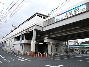
Dōtoku Station
Appearance
Dōtoku Station 道徳駅 | |
|---|---|
 The West gate, May 2007 | |
| General information | |
| Location | Toyoda 1-chome, Minami, Nagoya, Aichi (愛知県名古屋市南区豊田一丁目) Japan |
| Operated by | Meitetsu |
| Line(s) | Tokoname Line |
| History | |
| Opened | 1912 |
| Passengers | |
| 2013 | 4,403 daily |
Dōtoku Station (道徳駅, Dōtoku-eki) is a railway station operated by Meitetsu's Tokoname Line located in Minami Ward, Nagoya, Aichi Prefecture, Japan. It is located 2.4 rail kilometers from the terminus of the line at Jingū-mae Station.[1]
History
Dōtoku Station was opened on February 18, 1912, as a station on the Aichi Electric Railway Company. The Aichi Electric Railway became part of the Meitetsu group on August 1, 1935. The station was closed in 1944, and reopened in October 1949. From 1983 to 1984, the tracks were elevated. On January 15, 2005, the Tranpass system of magnetic fare cards with automatic turnstiles was implemented.
Lines
Layout
Dōtoku Station has one elevated island platform.
Platforms
| 1 | ■ Tokoname Line | for Central Japan International Airport , Kowa and Utsumi |
| 2 | ■ Tokoname Line | for Kanayama and Nagoya |
Adjacent stations
| ← | Service | → | ||
|---|---|---|---|---|
| Tokoname Line | ||||
| μSKY Limited Express (ミュースカイ): Does not stop at this station | ||||
| Limited Express (特急): Does not stop at this station | ||||
| Rapid Express (快速急行): Does not stop at this station | ||||
| Express (急行): Does not stop at this station | ||||
| Semi Express (準急): Does not stop at this station | ||||
| Toyodahommachi | Local (普通) | Ōe | ||
External links
- (in Japanese) Meitetsu Station information
Wikimedia Commons has media related to Dotoku Station.
Notes
35°06′20″N 136°54′34″E / 35.1056°N 136.9094°E
