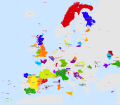
File:Active separatist movements in Europe.svg

Size of this PNG preview of this SVG file: 692 × 599 pixels. Other resolutions: 277 × 240 pixels | 554 × 480 pixels | 887 × 768 pixels | 1,183 × 1,024 pixels | 2,365 × 2,048 pixels | 873 × 756 pixels.
Original file (SVG file, nominally 873 × 756 pixels, file size: 4.36 MB)
File history
Click on a date/time to view the file as it appeared at that time.
| Date/Time | Thumbnail | Dimensions | User | Comment | |
|---|---|---|---|---|---|
| current | 14:39, 1 March 2022 |  | 873 × 756 (4.36 MB) | Jirka.h23 | Reverted to version as of 16:14, 13 March 2019 (UTC). Do not revert to so old map, if you see errors, write it to the discussion. |
| 12:48, 5 May 2019 |  | 873 × 756 (5.09 MB) | Koreanovsky | This version before has a lot of incorrect information and promotes irredentism - you can even find movements like "Herzegovina" or "Samogitia" which do not exist! | |
| 16:14, 13 March 2019 |  | 873 × 756 (4.36 MB) | Gk sa | Previous revert to a file version almost three years older than this one appears to be either accidental or vandalism, with no stated reason for the revision - Reverted to version as of 19:05, 6 January 2017 (UTC) | |
| 12:18, 15 September 2018 |  | 873 × 756 (5.09 MB) | Koreanovsky | Reverted to version as of 00:38, 17 May 2014 (UTC) | |
| 19:05, 6 January 2017 |  | 873 × 756 (4.36 MB) | Rob984 | Removed dotted overlay for the Irish state. Consistency: no other unification movements are indicated like this (Flanders, Wallonia, Crimea, Hungarian minorities, etc.) | |
| 08:06, 25 November 2016 |  | 873 × 756 (4.36 MB) | Elevatorrailfan | Removing Donetsk duplicates. | |
| 16:32, 24 November 2016 |  | 873 × 756 (4.37 MB) | Elevatorrailfan | Splitting Donbass into Donetsk and Lugansk. | |
| 10:34, 2 June 2016 |  | 873 × 756 (4.27 MB) | Rob984 | Added Donbass. | |
| 11:40, 1 June 2016 |  | 873 × 756 (4.25 MB) | Rob984 | Added Crimea | |
| 10:44, 1 June 2016 |  | 873 × 756 (4.25 MB) | Rob984 | Removed non-existent separatist and autonomist movements in England (Devon, Mercia, Isle of Wight, Scilly, Northumberland) and the Channel Islands. |
File usage
No pages on the English Wikipedia use this file (pages on other projects are not listed).
Global file usage
The following other wikis use this file:
- Usage on ar.wikipedia.org
- Usage on ast.wikipedia.org
- Usage on eo.wikipedia.org
- Usage on fr.wikipedia.org
- Usage on gl.wikipedia.org
- Usage on ko.wikipedia.org
- Usage on nl.wikipedia.org
- Usage on rm.wikipedia.org
- Usage on ru.wikinews.org
- Usage on sh.wikipedia.org
- Usage on zh.wikipedia.org
