
File:Bartrams Bridge NRHP.JPG

Size of this preview: 799 × 599 pixels. Other resolutions: 320 × 240 pixels | 640 × 480 pixels | 1,024 × 768 pixels | 1,280 × 960 pixels | 2,349 × 1,762 pixels.
Original file (2,349 × 1,762 pixels, file size: 2.03 MB, MIME type: image/jpeg)
| This is a file from the Wikimedia Commons. Information from its description page there is shown below. Commons is a freely licensed media file repository. You can help. |
Summary
| Description |
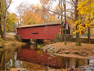
English: Bartram's Covered Bridge on the NRHP since December 10, 1980, West of Newtown on Legislative Route 15098 (Goshen Road, near intersection with Boot Road) in Newtown Township, Delaware County, Pennsylvania. Extends over Crum Creek into Willistown Township in Chester County.
|
||
| Date | |||
| Source | Own work | ||
| Author | Smallbones |
| Camera location | | View this and other nearby images on: OpenStreetMap |
|---|
Licensing
| I, the copyright holder of this work, release this work into the public domain. This applies worldwide. In some countries this may not be legally possible; if so: I grant anyone the right to use this work for any purpose, without any conditions, unless such conditions are required by law. |
File history
Click on a date/time to view the file as it appeared at that time.
| Date/Time | Thumbnail | Dimensions | User | Comment | |
|---|---|---|---|---|---|
| current | 16:36, 1 November 2010 | | 2,349 × 1,762 (2.03 MB) | Smallbones | {{Information |Description={{en|1=Bartram's Covered Bridge on the NRHP since December 10, 1980, West of Newtown on Legislative Route 15098 (Boots Road) in Newtown Township, Delaware County, Pennsylvania. Extends over Chester Creek into Willistown Township |
File usage
The following pages on the English Wikipedia use this file (pages on other projects are not listed):
Global file usage
The following other wikis use this file:
- Usage on ceb.wikipedia.org
- Usage on frr.wikipedia.org
- Usage on www.wikidata.org