
File:CBP Sectors Map.jpg

Size of this preview: 800 × 533 pixels. Other resolutions: 320 × 213 pixels | 640 × 426 pixels | 1,023 × 681 pixels.
Original file (1,023 × 681 pixels, file size: 153 KB, MIME type: image/jpeg)
| This is a file from the Wikimedia Commons. Information from its description page there is shown below. Commons is a freely licensed media file repository. You can help. |
Summary
| Description |
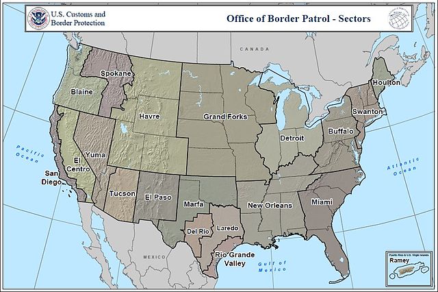
English: Map of the U.S. Customs and Border Patrol sectors |
| Source | http://www.cbp.gov/linkhandler/cgov/careers/customs_careers/border_careers/bp_agent/sectors_map.ctt/Sectors_Map.pdf |
| Author | U.S. Customs and Border Patrol |
Licensing
This image or file is a work of a United States Department of Homeland Security employee, taken or made as part of that person's official duties. As a work of the U.S. federal government, the image is in the public domain in the United States.
|
 |
File history
Click on a date/time to view the file as it appeared at that time.
| Date/Time | Thumbnail | Dimensions | User | Comment | |
|---|---|---|---|---|---|
| current | 18:18, 5 September 2010 | | 1,023 × 681 (153 KB) | Wnt | {{Information |Description={{en|1=Map of the U.S. Customs and Border Patrol sectors}} |Source=http://www.cbp.gov/linkhandler/cgov/careers/customs_careers/border_careers/bp_agent/sectors_map.ctt/Sectors_Map.pdf |Author=U.S. Customs and Border Patrol |Date= |
File usage
The following pages on the English Wikipedia use this file (pages on other projects are not listed):
Global file usage
The following other wikis use this file:
- Usage on uk.wikipedia.org