
File:Clavering 1932.tif

Size of this PNG preview of this TIF file: 800 × 467 pixels. Other resolutions: 320 × 187 pixels | 640 × 373 pixels | 1,013 × 591 pixels.
Original file (1,013 × 591 pixels, file size: 1.13 MB, MIME type: image/tiff)
| This is a file from the Wikimedia Commons. Information from its description page there is shown below. Commons is a freely licensed media file repository. You can help. |
Summary
| Description |
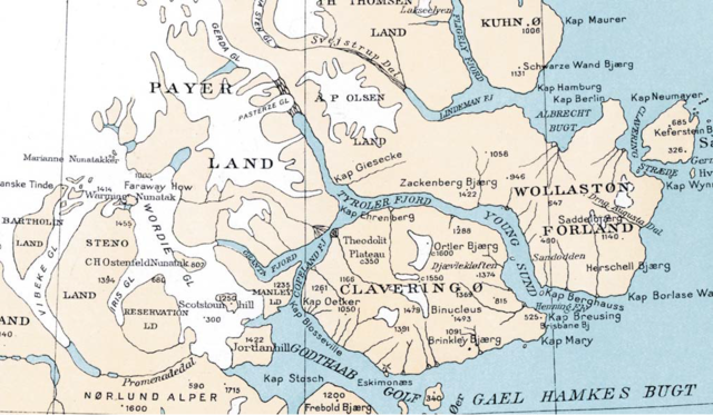
English: map of a coastal section of Northeast Greenland, with Clavering Ø, Wollaston Foreland, Sabine Ø, and Kuhn Ø (part), drawn during Lauge Koch's Treårsekspeditionen 1931-1934 |
| Date | |
| Source | http://www.geus.dk/publications/bull/nr21/nr21_p001-368.pdf, page 41 |
| Author | Geodætisk Institut, København |
Licensing
|
This work is in the public domain in its country of origin and other countries and areas where the copyright term is the author's life plus 70 years or fewer. | |
| This file has been identified as being free of known restrictions under copyright law, including all related and neighboring rights. | |
File history
Click on a date/time to view the file as it appeared at that time.
| Date/Time | Thumbnail | Dimensions | User | Comment | |
|---|---|---|---|---|---|
| current | 09:30, 23 September 2015 |  | 1,013 × 591 (1.13 MB) | Ratzer | {{Information |Description ={{en|1=map of a coastal section of Northeast Greenland, with Clavering Ø, Wollaston Foreland, Sabine Ø, and Kuhn Ø (part), drawn during Lauge Koch's Treårsekspeditionen 1931-1934}} |Source =http://www.geus.dk/... |
File usage
The following pages on the English Wikipedia use this file (pages on other projects are not listed):
Global file usage
The following other wikis use this file:
- Usage on arz.wikipedia.org
- Usage on da.wikipedia.org
- Usage on de.wikipedia.org
- Usage on gl.wikipedia.org
- Usage on id.wikipedia.org
- Usage on ru.wikipedia.org
- Usage on www.wikidata.org