
File:Crooked Creek Crater tectonic structures v4.svg

Size of this PNG preview of this SVG file: 550 × 599 pixels. Other resolutions: 220 × 240 pixels | 441 × 480 pixels | 705 × 768 pixels | 940 × 1,024 pixels | 1,880 × 2,048 pixels | 994 × 1,083 pixels.
Original file (SVG file, nominally 994 × 1,083 pixels, file size: 2.94 MB)
| This is a file from the Wikimedia Commons. Information from its description page there is shown below. Commons is a freely licensed media file repository. You can help. |
Summary
| Description |
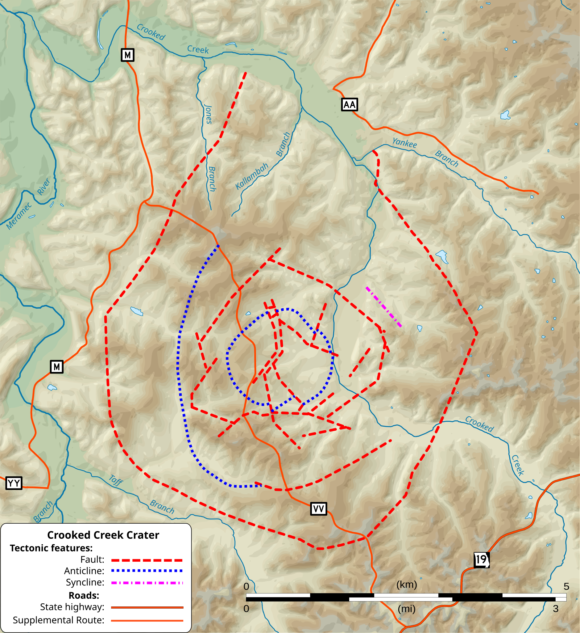
English: Fault and related tectonic structures of the Crooked Creek crater in Crawford County, Missouri shown on a shaded relief map. Tectonic features from MO 2010 Tectonic Fault Structures (2010-03-24), Missouri Department of Natural Resources (MoDNR), Division of Geology and Land Survey (DGLS), Geological Survey Program (GSP); Jefferson City, Missouri: GIS shapefile. Terrain, roads, streams and waterbody GIS data from The National Map of the United States. |
| Date | |
| Source | Own work |
| Author | Kbh3rd |
| Other versions |
This version of the map is pure SVG with reduced resolution terrain shading compared to the bitmap or hybrid SVG/bitmap versions. Others are:
|


| Geographic coordinates | ||
|---|---|---|
| Location | Latitude | Longitude |
| Center | 37°50'26.49" | 91°23'32.30"W |
| Lower Left | 37°47'51.86" | 91°26'37.39"W |
| Lower Right | 37°47'46.91" | 91°20'34.04"W |
| Upper Left | 37°53' 6.01" | 91°26'30.79"W |
| Upper Right | 37°53' 1.04" | 91°20'27.00"W |
| NAD83 / UTM zone 15N | ||
|---|---|---|
| Location | Easting | Northing |
| Center | 641460.593 | 4189357.517 |
| Lower Left | 637015.895 | 4184514.853 |
| Lower Right | 645905.291 | 4184514.853 |
| Upper Left | 637015.895 | 4194200.181 |
| Upper Right | 645905.291 | 4194200.181 |
World file
For NAD83 / UTM zone 15N:
8.943055
0
0
-8.943055
637015
4194200
Licensing
I, the copyright holder of this work, hereby publish it under the following licenses:
This file is licensed under the Creative Commons Attribution-Share Alike 3.0 Unported license.
- You are free:
- to share – to copy, distribute and transmit the work
- to remix – to adapt the work
- Under the following conditions:
- attribution – You must give appropriate credit, provide a link to the license, and indicate if changes were made. You may do so in any reasonable manner, but not in any way that suggests the licensor endorses you or your use.
- share alike – If you remix, transform, or build upon the material, you must distribute your contributions under the same or compatible license as the original.

|
Permission is granted to copy, distribute and/or modify this document under the terms of the GNU Free Documentation License, Version 1.2 or any later version published by the Free Software Foundation; with no Invariant Sections, no Front-Cover Texts, and no Back-Cover Texts. A copy of the license is included in the section entitled GNU Free Documentation License. |
You may select the license of your choice.
File history
Click on a date/time to view the file as it appeared at that time.
| Date/Time | Thumbnail | Dimensions | User | Comment | |
|---|---|---|---|---|---|
| current | 00:44, 21 September 2012 | | 994 × 1,083 (2.94 MB) | Kbh3rd | {{Information |Description ={{en|1=Fault and related tectonic structures of the Crooked Creek crater in Crawford County, Missouri shown on a shaded relief map. Tectonic ... |
File usage
The following pages on the English Wikipedia use this file (pages on other projects are not listed):
Global file usage
The following other wikis use this file:
- Usage on pl.wikipedia.org