
File:Map of Jewish settlements in Palestine in 1947.png
No higher resolution available.
Map_of_Jewish_settlements_in_Palestine_in_1947.png (312 × 556 pixels, file size: 59 KB, MIME type: image/png)
| This is a file from the Wikimedia Commons. Information from its description page there is shown below. Commons is a freely licensed media file repository. You can help. |
Summary
| Description |
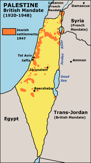
English: Map of Jewish settlements in Palestine in 1947. |
| Date | 2 October 2003 (original upload date) |
| Source | Transferred from en.wikipedia to Commons using CommonsHelper. |
| Author | JamesDay at English Wikipedia |
| Permission (Reusing this file) |
GFDL derivative work created by the uploader based on a portion of the public domain work http://www.lib.utexas.edu/maps/historical/israel_hist_1973.jpg . At http://www.lib.utexas.edu/maps/faq.html that site states that "Most of the maps scanned by the General Libraries and served from this web site are in the public domain. No permissions are needed to copy them. You may download them and use them as you wish. A few maps are copyrighted, and are clearly marked as such". There is no such mark with this map, so it is presumed to have been in the public domain before the derivative work was created. The uploader hereby releases the derivative work under the GFDL. |
Licensing

|
Permission is granted to copy, distribute and/or modify this document under the terms of the GNU Free Documentation License, Version 1.2 or any later version published by the Free Software Foundation; with no Invariant Sections, no Front-Cover Texts, and no Back-Cover Texts. A copy of the license is included in the section entitled GNU Free Documentation License. |
| This file is licensed under the Creative Commons Attribution-Share Alike 3.0 Unported license. | ||
| Attribution: Wikipedia user JamesDay | ||
| ||
| This licensing tag was added to this file as part of the GFDL licensing update. |
Original upload log
The original description page was here. All following user names refer to en.wikipedia.
- 2005-09-27 18:47 Doviende 312×556× (60723 bytes) changed from indexed colour to RGB and traced the lines again so they aren't so choppy. Also redid all the text so it's anti-aliased better.
- 2003-10-02 14:18 JamesDay 312×556× (11422 bytes) Map of Jewish settlements in Palestine in 1947.
File history
Click on a date/time to view the file as it appeared at that time.
| Date/Time | Thumbnail | Dimensions | User | Comment | |
|---|---|---|---|---|---|
| current | 16:13, 18 December 2006 | | 312 × 556 (59 KB) | Electionworld | {{ew|en|JamesDay}} Map of Jewish settlements in Palestine in 1947. Copyright: GFDL derivative work created by the uploader based on a portion of the public domain work http://www.lib.utexas.edu/maps/historical/israel_hist_1973.jpg . At http://www.lib.ute |
File usage
The following pages on the English Wikipedia use this file (pages on other projects are not listed):
Global file usage
The following other wikis use this file:
- Usage on als.wikipedia.org
- Usage on ast.wikipedia.org
- Usage on de.wikipedia.org
- Usage on es.wikipedia.org
- Usage on fi.wikipedia.org
- Usage on gl.wikipedia.org
- Usage on it.wikipedia.org
- Usage on sq.wikipedia.org
- Usage on stq.wikipedia.org