
File:Map of the Kiel Canal.png

Size of this preview: 773 × 600 pixels. Other resolutions: 310 × 240 pixels | 619 × 480 pixels | 990 × 768 pixels | 1,280 × 993 pixels | 1,814 × 1,407 pixels.
Original file (1,814 × 1,407 pixels, file size: 1.69 MB, MIME type: image/png)
| This is a file from the Wikimedia Commons. Information from its description page there is shown below. Commons is a freely licensed media file repository. You can help. |
| Description |
Cebuano: Mapa sa Kiel Canal
Dansk: Kort over Kielerkanalen
Deutsch: Karte des Nord-Ostsee-Kanals
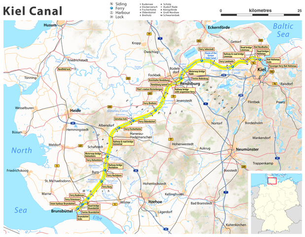
English: Map of the Kiel Canal
Español: Mapa del Canal de Kiel
Français : Carte du canal de Kiel
Italiano: Mappa del Canale di Kiel
Nederlands: Kaart van het Noord-Oostzeekanaal
Polski: Mapa Kanału Kilońskiego
Português: Mapa do Canal de Quiel
Русский: Карта Кильского канала
Svenska: Karta över Kielkanalen
Tiếng Việt: Bản đồ kênh đào Kiel
Українська: Карта Кільського каналу
日本語: キール運河の地図
中文:基爾運河地圖 |
| Date | see file history |
| Source |
own work, using
|
| Author | Maximilian Dörrbecker (Chumwa) |
| Permission (Reusing this file) |
All OpenStreetMap data and maps are Creative Commons "CC-BY-SA 2.0" licensed This file is licensed under the Creative Commons Attribution-Share Alike 2.0 Generic license.
|
| Other versions |
|


File history
Click on a date/time to view the file as it appeared at that time.
| Date/Time | Thumbnail | Dimensions | User | Comment | |
|---|---|---|---|---|---|
| current | 20:26, 14 September 2011 | | 1,814 × 1,407 (1.69 MB) | Chumwa | {{Information |Description={{de|Karte des Nord-Ostsee-Kanals}} {{en|Map of the Kiel Canal}} |Author=Maximilian Dörrbecker (Chumwa) |Source=own work, using * OpenStreetMap data for the background * topographical |
File usage
The following pages on the English Wikipedia use this file (pages on other projects are not listed):
Global file usage
The following other wikis use this file:
- Usage on bh.wikipedia.org
- Usage on bn.wikipedia.org
- Usage on el.wikipedia.org
- Usage on hi.wikipedia.org
- Usage on is.wikipedia.org
- Usage on sl.wikipedia.org
- Usage on th.wikipedia.org
- Usage on vi.wikipedia.org
- Usage on zh-yue.wikipedia.org