
File:Mount Hachino 20120401.jpg

Size of this preview: 800 × 534 pixels. Other resolutions: 320 × 213 pixels | 640 × 427 pixels | 1,000 × 667 pixels.
Original file (1,000 × 667 pixels, file size: 84 KB, MIME type: image/jpeg)
| This is a file from the Wikimedia Commons. Information from its description page there is shown below. Commons is a freely licensed media file repository. You can help. |
Summary
| Description |
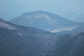
English: Mount Hachino (Hachino-yama) as seen from the NNE in Kawazu, Shizuoka Prefecture, Japan. Mount Hachino is a one of the cinder cone volcano of the Izu-tobu Volcano Group. Taken from Mount Amagi.
|
||
| Date | |||
| Source | Own work | ||
| Author | Batholith | ||
| Permission (Reusing this file) |
|
| Camera location | | View this and other nearby images on: OpenStreetMap |
|---|
| Object location | | View this and other nearby images on: OpenStreetMap |
|---|
File history
Click on a date/time to view the file as it appeared at that time.
| Date/Time | Thumbnail | Dimensions | User | Comment | |
|---|---|---|---|---|---|
| current | 16:27, 19 April 2012 | | 1,000 × 667 (84 KB) | Batholith | {{Information |Description={{en|Mount Hachino (鉢ノ山) scoria cone is one of the Izu tobu volcano field, located in Kawazu town, Shizuoka prefecture, Japan.}}{{ja|[[... |
File usage
The following pages on the English Wikipedia use this file (pages on other projects are not listed):
Global file usage
The following other wikis use this file:
- Usage on ja.wikipedia.org