Garbh Uisge
Appearance
| Garbh Uisge River Leny | |
|---|---|
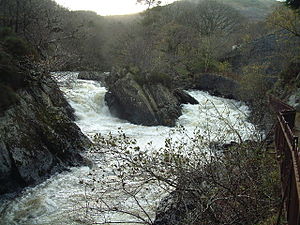
 The Falls of Leny, upstream from Kilmahog | |
 | |
| Location | |
| Country | United Kingdom |
| Constituent country | Scotland |
| Physical characteristics | |
| Source | |
| • location | Loch Lubnaig |
| Mouth | River Teith |
• location | Callander |
• coordinates | 56°14′29″N 4°13′28″W / 56.24132°N 4.22443°W |
| Discharge | |
| • location | River Teith |
Garbh Uisge is a river of approximately 7 km in the Trossachs of Scotland just north-west Callander.[1][2] It is the outflow of Loch Lubnaig and joins with Eas Gobhain west of Callander to form the River Teith. The name of the river, Garbh Uisge, is Gaelic for "Rough Water", reflecting the nature of the river. The river is often informally called the River Leny due to the Falls of Leny, where the river crosses the Highland Boundary Fault, and because it flows through the Pass of Leny.
References
- ^ Ordnance Survey: Landranger map sheet 25 Glen Carron & Glen Affric (Map). Ordnance Survey. 2011. ISBN 9780319231111.
- ^ "Ordnance Survey: 1:50,000 Scale Gazetteer" (csv (download)). www.ordnancesurvey.co.uk. Ordnance Survey. 1 January 2016. Retrieved 18 February 2016.
56°14′36″N 4°13′50″W / 56.24339°N 4.23051°W
