
Grabowo Królewskie
Grabowo Królewskie | |
|---|---|
Village | |
 Grabowo Królewskie | |
| Coordinates: 52°14′28″N 17°37′16″E / 52.24111°N 17.62111°E | |
| Country | |
| Voivodeship | Greater Poland |
| County | Września |
| Gmina | Kołaczkowo |
Grabowo Królewskie [ɡraˈbɔvɔ kruˈlɛfskʲɛ] is a village in the administrative district of Gmina Kołaczkowo, within Września County, Greater Poland Voivodeship, in west-central Poland.[1] It lies approximately 11 kilometres (7 mi) south of Września and 52 km (32 mi) east of the regional capital Poznań.
Mansion in Grabowo Krolewskie[edit]
| Royal Manor in Grabow | |
|---|---|
 | |
 | |
| General information | |
| Type | court |
| Location | Grabowo Królewskie, Poland |
| Country | Poland |
| Owner | Gmina Września |
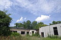
Mansion in Grabowo Królewskie is the ruins of a building from the interwar period, located in Grabowo Królewskie, part of Greater Poland Voivodeship. The mansion in Grabowo Krolewskie was built in 1928. It was entered into the registry of monuments in 1998. The mansion belonged to the owner of the village, Witold Wilkoszewski (November 22, 1881 - April 17, 1937). After World War II, it housed a lounge and a library. The manor house was surrounded by a garden. In his area, he placed concrete and plaster figurines of saints, farmers, and cupids. In 1928, the park was surrounded by a fence with gates.
Gallery[edit]
-
 The gate to the park
 -
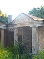 The ruins of the manor
 -
 Front view of the Palace
 -
 View of the figurine
 -
 View of the Palace from Behind

.jpg)


See also[edit]
References[edit]
This Września County location article is a stub. You can help Wikipedia by expanding it. |