
Great Esker Park
| Great Esker Park | |
|---|---|
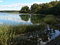
_end_July_2012.jpg) Looking up the Weymouth Back River from Great Esker Park, the esker is the tree-covered low ridge on the right. | |
 | |
| Type | Urban park |
| Location | Weymouth, Massachusetts |
| Coordinates | 42°14′12″N 70°55′47″W / 42.23667°N 70.92972°W |
| Area | 237 acres (96 ha) |
Great Esker Park is located in Weymouth, Massachusetts. The park mostly consists of a geological formation known as an esker (a winding ridge of stratified sand and gravel) formed by a glacier 12,000 years ago. It is located along the Weymouth Back River, across from Bare Cove Park in Hingham, Massachusetts.[1]
The park features the highest esker in North America (90 ft), reversing falls, salt marshes, six miles (10 km) of trails, a playground and picnic area. Bird watching is a popular activity as osprey, great blue heron, red-tailed hawks, owls, and other species of birds are abundant seasonally. There are man-made shelters on the river where Osprey nest in the spring and summer months.
In the summer months the park is used by Wey-Rec for children's programs.[clarification needed]
Image gallery
-
 Fishing in Back River
 -
 Trail climbs the esker
 -
 Egret
Egret -
 Back River


See also
References
- ^ "Hiking Trails for Day Hikes out of Boston". Appalachian Mountain Club Boston Chapter Local Walks/Hikes Committee. Retrieved 2012-08-04.
External links
- Weymouth Back River Reservation map
- Weymouth's Great Esker park, an interesting geological formation along the Back River
- Great Esker Park in Weymouth
- Back River Bob-Obituary