Hermansville, Michigan
Appearance
Hermansville, Michigan | |
|---|---|
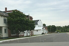
 Looking east at downtown Hermansville | |
| Coordinates: 45°39′53″N 87°45′06″W / 45.66472°N 87.75167°W | |
| Country | United States |
| State | Michigan |
| County | Menominee |
| Township | Meyer |
| Time zone | UTC-6 (Central (CST)) |
| • Summer (DST) | UTC-5 (CDT) |
| ZIP code(s) | 49847 |
| Area code | 906 |
| Designated | September 17, 1974 |
Hermansville is an unincorporated community and census-designated place (CDP) in Meyer Township of Menominee County in the U.S. state of Michigan.[1] It formed around the defunct Wisconsin Land & Lumber Company as a company town . The company's former headquarters is open as the IXL Historical Museum. US Highway 2 (US 2) passes through the north edge of the community.
Hermansville was established in 1878. The community was named for the son of the original owner of the town site.[2]
Images
-
Post office
-
Arrow on US 2
References
- ^ "Hermansville, Michigan". Geographic Names Information System. United States Geological Survey, United States Department of the Interior.
- ^ Chicago and North Western Railway Company (1908). A History of the Origin of the Place Names Connected with the Chicago & North Western and Chicago, St. Paul, Minneapolis & Omaha Railways. p. 83.
Categories:
- Census-designated places in Michigan
- Census-designated places in Menominee County, Michigan
- Unincorporated communities in Michigan
- Unincorporated communities in Menominee County, Michigan
- Marinette micropolitan area
- Company towns in Michigan
- Populated places established in 1878
- 1878 establishments in Michigan
- Upper Peninsula, Michigan, geography stubs


