
Ignalina District Municipality
(Redirected from Ignalina district municipality)
Ignalina District Municipality
Ignalinos rajono savivaldybė | |
|---|---|
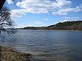
 Žaliasis lake | |
.svg) Coat of arms | |
 Location of Ignalina District Municipality within Lithuania | |
 Location of Ignalina | |
| Coordinates: 55°20′24″N 26°9′41″E / 55.34000°N 26.16139°E | |
| Country | |
| Region | Aukštaitija |
| County | Utena County |
| Established | 1950 |
| Capital | Ignalina |
| Elderships | 12 |
| Government | |
| • Type | City Council |
| • Body | Ignalina District Council |
| • Mayor | Laimutis Ragaišis (LVŽS) |
| • Leading | Farmers and Greens Union[1] 10 / 21
|
| Area | |
| • Total | 1,441 km2 (556 sq mi) |
| • Rank | 18th |
| Population (2022[2]) | |
| • Total | 14,283 |
| • Rank | 54th |
| • Density | 9.91/km2 (25.7/sq mi) |
| • Rank | 59th |
| Time zone | UTC+2 (EET) |
| • Summer (DST) | UTC+3 (EEST) |
| ZIP Codes | 30012–30620 |
| Phone code | +370 (386) |
| Website | www |
Ignalina District Municipality is one of 60 municipalities in Lithuania.[3]
Structure[edit]
District structure:
- 2 cities – Dūkštas and Ignalina;
- 3 towns – Mielagėnai, Rimšė and Tverečius;
- 726 villages.
- Ignalina District Municipality consists of 12 smaller administration units - elderships.
Population of largest Ignalina District Municipality elderships (2014-07-01):
- Ignalina town – 5605
- Didžiasalis – 1691
- Vidiškės – 1278
- Dūkštas – 1756
- Kazitiškis – 1039
- Naujasis Daugėliškis – 1491
- Mielagėnai – 887
- Ceikiniai – 533
- Linkmenys – 970
- Rimšė – 999
- Tverečius – 590
In total - 18414 inhabitants.
Elderships[edit]
Ignalina District Municipality is divided into 12 elderships:
| Eldership (Administrative Center) | Area | Population (2021) |
|---|---|---|
| Ceikiniai (Ceikiniai) | 83 km2 (20,509.75 acres; 32.05 sq mi) | 441 |
| Didžiasalis (Didžiasalis) | 82.2 km2 (20,312.06 acres; 31.74 sq mi) | 1,222 |
 |
154 km2 (38,054.23 acres; 59.46 sq mi) | 1,291 |
|
6.9 km2 (1,705.03 acres; 2.66 sq mi) | 5,106 |
|
262 km2 (64,741.61 acres; 101.16 sq mi) | 1,380 |
| Kazitiškis (Kazitiškis) | 162 km2 (40,031.07 acres; 62.55 sq mi) | 763 |
| Linkmenys (Linkmenys) | 96 km2 (23,722.12 acres; 37.07 sq mi) | 763 |
 |
115 km2 (28,417.12 acres; 44.40 sq mi) | 639 |
| Naujasis Daugėliškis (Naujasis Daugėliškis) | 160 km2 (39,536.86 acres; 61.78 sq mi) | 1,072 |
| Rimšė (Rimšė) | 98 km2 (24,216.33 acres; 37.84 sq mi) | 624 |
| Tverečius (Tverečius) | 79 km2 (19,521.33 acres; 30.50 sq mi) | 382 |
 |
62 km2 (15,320.53 acres; 23.94 sq mi) | 1,099 |
Nature and geography[edit]
-
-
 Rock of Pliateriai
 -
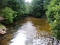 The Srovė river


_1.jpg)
See also[edit]
References[edit]

This Lithuanian location article is a stub. You can help Wikipedia by expanding it. |