File:Ct norwich-new london ua.png
Appearance
Ct_norwich-new_london_ua.png (450 × 330 pixels, file size: 16 KB, MIME type: image/png)
Summary
[edit]| Description |
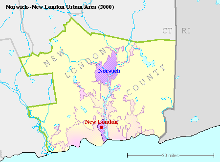
Small map showing Norwich--New London Urban Area (2000). | ||
|---|---|---|---|
| Source |
Derived from U.S. Census Bureau Reference Maps accessible via http://factfinder.census.gov/jsp/saff/SAFFInfo.jsp?_pageId=referencemaps&_submenuId=maps_2. | ||
| Date | |||
| Author |
| ||
| Permission (Reusing this file) |
See below.
|
Licensing
[edit]| This image is a work of a United States Census Bureau employee, taken or made as part of that person's official duties. As a work of the U.S. federal government, the image is in the public domain in the United States. |  |
 | This file is a candidate to be copied to Wikimedia Commons.
Any user may perform this transfer; refer to Wikipedia:Moving files to Commons for details. If this file has problems with attribution, copyright, or is otherwise ineligible for Commons, then remove this tag and DO NOT transfer it; repeat violators may be blocked from editing. Other Instructions
| ||
| |||
File history
Click on a date/time to view the file as it appeared at that time.
| Date/Time | Thumbnail | Dimensions | User | Comment | |
|---|---|---|---|---|---|
| current | 23:48, 5 December 2006 |  | 450 × 330 (16 KB) | OWL (talk | contribs) | Small map showing Norwich--New London Urban Area (2000). Derived from U.S. Census Bureau Reference Maps accessible via http://factfinder.census.gov/jsp/saff/SAFFInfo.jsp?_pageId=referencemaps&_submenuId=maps_2. |
You cannot overwrite this file.
File usage
The following page uses this file:

