
File:NYP LOC5.jpg
Size of this preview: 424 × 599 pixels. Other resolutions: 170 × 240 pixels | 340 × 480 pixels | 544 × 768 pixels | 725 × 1,024 pixels | 1,450 × 2,048 pixels | 3,280 × 4,632 pixels.
Original file (3,280 × 4,632 pixels, file size: 6.27 MB, MIME type: image/jpeg)
| This is a file from the Wikimedia Commons. Information from its description page there is shown below. Commons is a freely licensed media file repository. You can help. |
Summary
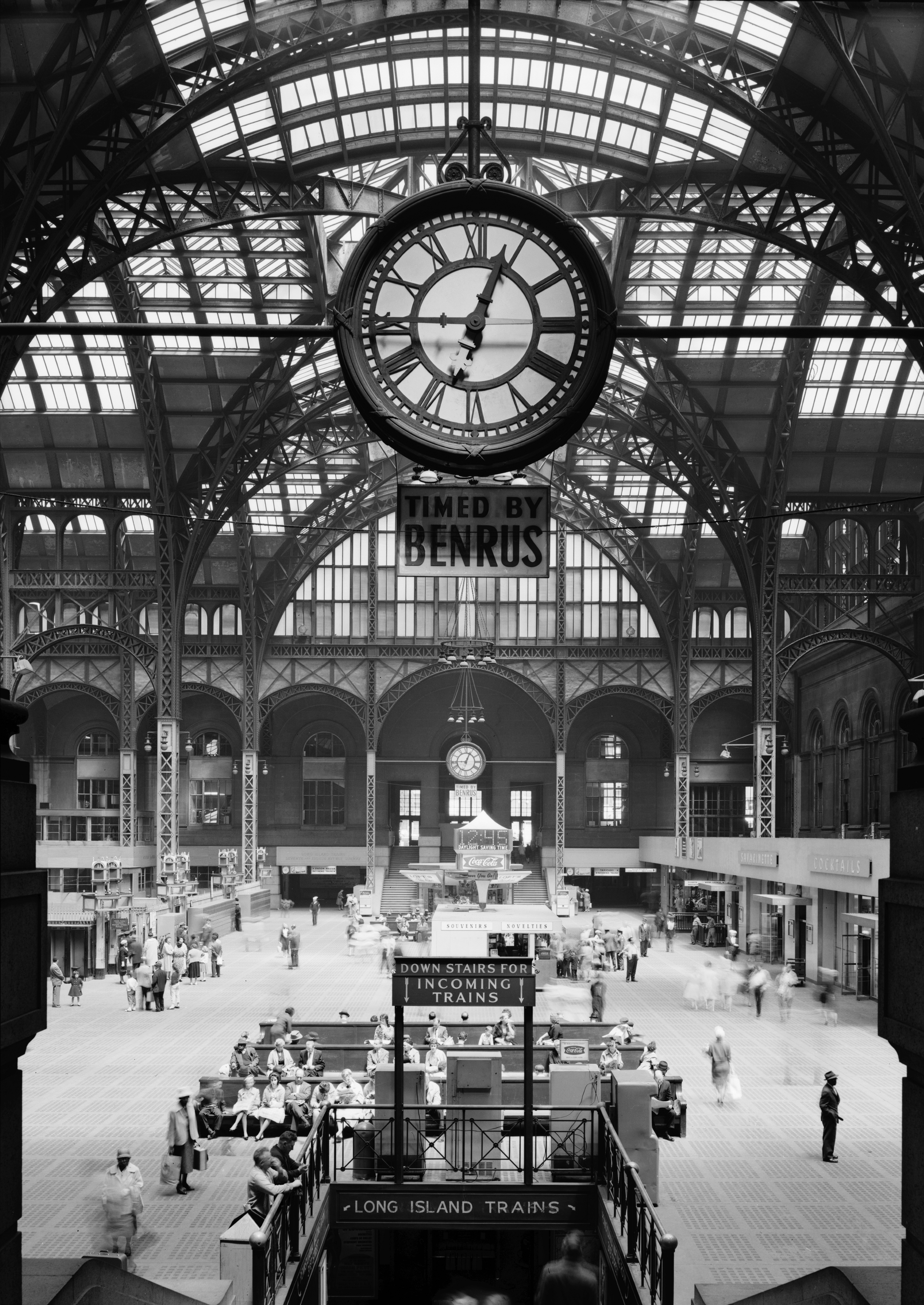
| English: Pennsylvania Station, New York City (demolished 1963)
( |
|||||||||||||||||||||||
|---|---|---|---|---|---|---|---|---|---|---|---|---|---|---|---|---|---|---|---|---|---|---|---|
| Author |
|
||||||||||||||||||||||
| Title |
English: Pennsylvania Station, New York City (demolished 1963) |
||||||||||||||||||||||
| Description |
English: 9. Historic American Buildings Survey, Cervin Robinson, Photographer April 24, 1962, CONCOURSE FROM SOUTH. - Pennsylvania Station, 370 Seventh Avenue, West Thirty-first, Thirty-first-Thirty-third Streets, New York, New York County, NY |
||||||||||||||||||||||
| Date | 24 April 1962 | ||||||||||||||||||||||
| Source |
|
||||||||||||||||||||||
| Permission (Reusing this file) |
HABS | ||||||||||||||||||||||
| Other versions |
|
||||||||||||||||||||||


| Camera location | | View this and other nearby images on: OpenStreetMap |
|---|
Licensing

|
This file comes from the Historic American Buildings Survey (HABS), Historic American Engineering Record (HAER) or Historic American Landscapes Survey (HALS). These are programs of the National Park Service established for the purpose of documenting historic places. Records consist of measured drawings, archival photographs, and written reports.
|
| This image or media file contains material based on a work of a National Park Service employee, created as part of that person's official duties. As a work of the U.S. federal government, such work is in the public domain in the United States. See the NPS website and NPS copyright policy for more information. |
File history
Click on a date/time to view the file as it appeared at that time.
| Date/Time | Thumbnail | Dimensions | User | Comment | |
|---|---|---|---|---|---|
| current | 00:42, 2 May 2011 | | 3,280 × 4,632 (6.27 MB) | Jklamo | hires from tiff |
| 17:27, 11 September 2010 |  | 700 × 946 (158 KB) | Cropbot | upload cropped version, operated by User:Dogears. Summary: cropped | |
| 01:58, 17 June 2009 |  | 726 × 1,024 (165 KB) | File Upload Bot (Magnus Manske) | {{BotMoveToCommons|en.wikipedia|year={{subst:CURRENTYEAR}}|month={{subst:CURRENTMONTHNAME}}|day={{subst:CURRENTDAY}}}} {{Information |Description={{en|'''en:Pennsylvania Station (New York City)'''<br> ::::Concourse view from south – [[:en:Apr |
File usage
The following pages on the English Wikipedia use this file (pages on other projects are not listed):
Global file usage
The following other wikis use this file:
- Usage on de.wikipedia.org
- Usage on es.wikipedia.org
- Usage on fr.wikipedia.org
- Usage on ja.wikipedia.org
- Usage on ko.wikipedia.org
- Usage on pt.wikipedia.org
- Usage on sv.wikipedia.org
- Usage on zh.wikipedia.org