Jemappes
You can help expand this article with text translated from the corresponding article in French. (November 2009) Click [show] for important translation instructions.
|
Jemappes | |
|---|---|
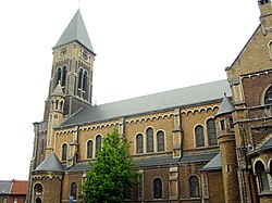
 St. Martin's Church (1863). | |
| Coordinates: 50°27′N 3°53′E / 50.450°N 3.883°E | |
| Country | |
| Region | Wallonia |
| Province | Hainaut |
| Arrondissement | Mons |
| Municipality | Mons |
| Area | |
| • Total | 6.72 km2 (2.59 sq mi) |
| Population (2004) | |
| • Total | 10,120 |
| Time zone | UTC+1 (CET) |
| • Summer (DST) | UTC+2 (CEST) |
Jemappes (French pronunciation: [ʒəmap]; in older texts also: Jemmapes; Walloon: Djumape) is a town of Wallonia and a district of the municipality of Mons, located in the province of Hainaut, Belgium.
It was a municipality until the fusion of the Belgian municipalities in 1973.
Jemappes is known for the Battle of Jemappes between the French and Austrian armies in 1792.
During the French occupation of Belgium (1792–1814), there was a département named after the Battle of Jemappes, Jemmape. Jemappes was also a battleground in the First World War.
Notable inhabitants
- Georges Emile Lebacq, painter born on 26 September 1876
- Jean-Marie Buchet, author-filmmaker born on 24 February 1938.
- Salvatore Adamo, singer, lived here 1948 - ?
- Gérard Roland, noted Economist, born in 1954.
Gallery
-
Old Town Hall.
Wikimedia Commons has media related to Jemappes.
50°27′N 3°53′E / 50.450°N 3.883°E


