
Käfertal (Mannheim)
Käfertal | |
|---|---|
 Coat of arms | |
Location of Käfertal (Mannheim)  | |
 Käfertal  Käfertal | |
| Coordinates: 49°31′N 8°31′E / 49.517°N 8.517°E | |
| Country | Germany |
| State | Baden-Württemberg |
| Admin. region | Karlsruhe |
| District | Urban district |
| City | Mannheim |
| Area | |
| • Total | 10.73 km2 (4.14 sq mi) |
| Population (2019-12-31)[1] | |
| • Total | 26,446 |
| • Density | 2,500/km2 (6,400/sq mi) |
| Time zone | UTC+01:00 (CET) |
| • Summer (DST) | UTC+02:00 (CEST) |
| Postal codes | 68309 |
| Website | Käfertal-Portal |
Käfertal is a borough (Stadtbezirk) of Mannheim, Baden-Württemberg, Germany in the Rhine-Neckar metropolitan region which is divided into the quarters Käfertal-Mitte, Speckweggebiet, Käfertal-Süd, Sonnenschein and Franklin. It has a population of 26,446 people as of December 31, 2019.[1]
Geography[edit]
Käfertal is located in the northeast of Mannheim. The neighboring districts are Vogelstang, Feudenheim, Wohlgelegen, and Waldhof. In the northeast is the city of Viernheim (Bergstraße district).
Gallery[edit]
-
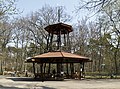 Karlsternpavillon in the Käfertaler Wald
 -
 Laurentiuskirche


Literature[edit]
- Lorenz Klingert: Festbuch zur Siebenjahrhundert-Feier der ehemaligen Gemeinde Käfertal 1227–1927. Mannheim 1927.
- Günter Bertschmann: Käfertal: 750 Jahre Käfertal 1227–1977. Mannheim 1977.
References[edit]
- ^ a b "Stadtbezirks- und Stadtteildaten auf einen Blick". Stadt Mannheim. Retrieved 23 September 2021.
External links[edit]
- Käfertal-Portal Official website (in German)
| Authority control databases: National |
|---|