
Kempen, Germany
(Redirected from Kempen (Germany))
Kempen | |
|---|---|
 Old School Street | |
 Coat of arms | |
Location of Kempen within Viersen district  | |
 Kempen  Kempen | |
| Coordinates: 51°21′57″N 6°25′10″E / 51.36583°N 6.41944°E | |
| Country | Germany |
| State | North Rhine-Westphalia |
| Admin. region | Düsseldorf |
| District | Viersen |
| Subdivisions | 4 |
| Government | |
| • Mayor (2020–25) | Christoph Dellmann[1] |
| Area | |
| • Total | 68.79 km2 (26.56 sq mi) |
| Highest elevation | 68 m (223 ft) |
| Lowest elevation | 30 m (100 ft) |
| Population (2023-12-31)[2] | |
| • Total | 34,888 |
| • Density | 510/km2 (1,300/sq mi) |
| Time zone | UTC+01:00 (CET) |
| • Summer (DST) | UTC+02:00 (CEST) |
| Postal codes | 47906 |
| Dialling codes | 02152 / 02845 |
| Vehicle registration | VIE / KK |
| Website | www |
Kempen (German: [ˈkɛmpm̩] ) is a town in the district of Viersen, in North Rhine-Westphalia, Germany. It is situated approximately 30 kilometres (19 mi) northwest of Düsseldorf, and 20 kilometres (12 mi) east of Venlo.
History
[edit]- 1186: First mention in official documentation of Kempen as a place – the sovereign until 1794 is the Archbishop (electoral prince) of Cologne
- around 1290: Kempen is rebuilt as a fortified town
- 11 March 1294: First confirmation of Kempen as a town in official documentation
- 15th century: town blooms economically and culturally (population of approx. 4,200)
- 1542–1543: Kempen is the centre of the Reformation for the Lower Rhine
- 1579: The plague costs the town almost half of its inhabitants
- 1642: Kempen is conquered and destroyed by the allied French, Hessian and Weimar troops during the "Hessen War" (Thirty Years' War)
- 1794–1814: Kempen is under French rule. In the département of Roer established in 1797, Kempen becomes a canton seat in 1798 and a French town in 1801.
- 1815: After the Congress of Vienna, Kempen becomes Prussian and is the county seat
- 1929: Due to local reforms, Kempen becomes the administrative seat of the county of Kempen-Krefeld
- 1966 onward: Restoration of the old town
- 1970: Communal restructuring: The communities of Hüls, St. Hubert, Tönisberg and Schmalbroich join Kempen along with the localities of St. Peter and Unterweiden to form a single town
- 1975: In further local reforms, Hüls is assigned to the city of Krefeld. The county of Viersen is formed and Kempen becomes part of "Kreis Viersen"
- 1984: The county seat is transferred from Kempen to Viersen.
- 1987: A cultural forum is opened in the Franciscan monastery after comprehensive restoration and renovation work.
- 11 March 1994: Date of the 700-year jubilee of the confirmation of Kempen as a town
Twin towns – sister cities
[edit] Wambrechies, France (1972)
- Orsay, France (1973)
 East Cambridgeshire, England, United Kingdom (1978)
 Werdau, Germany (1990)
Notable people
[edit]- Thomas à Kempis (c. 1380–1471)
- John Brugman (?–1473), Franciscan friar and preacher in Flanders
- Wilhelm Hünermann (1900–1975), priest and writer
- Adolph Moses Radin (1848–1909), rabbi
- Isabel Varell (born 1961), actress and singer
- Bernhard van Treeck (born 1964), psychiatrist and author
- Tobias Koch (born 1968), pianist
- Daniel Altmaier (born 1998), Tennis player
Gallery
[edit]-
 View in a street
 -
 Church
 -
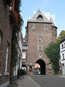 Towngate (Das Kuhtor)
 -
 Lutheran church (Thomas Church)
 -
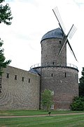 Hessenmühle
 -
 Kempen Castle


.jpg)

References
[edit]- ^ Wahlergebnisse in NRW Kommunalwahlen 2020, Land Nordrhein-Westfalen, accessed 30 June 2021.
- ^ "Bevölkerung der Gemeinden Nordrhein-Westfalens am 31. Dezember 2023 – Fortschreibung des Bevölkerungsstandes auf Basis des Zensus vom 9. Mai 2011" (in German). Landesbetrieb Information und Technik NRW. Retrieved 20 June 2024.
- ^ "Partnerstädte". kempen.de (in German). Kempen. Retrieved 28 February 2021.
External links
[edit]Wikimedia Commons has media related to Kempen (Niederrhein).
- Official website
 (in German)
Towns and municipalities in Viersen (district) | ||
|---|---|---|
 | ||
![]() This article incorporates text from a publication now in the public domain: Wood, James, ed. (1907). "Kempen". The Nuttall Encyclopædia. London and New York: Frederick Warne.
This article incorporates text from a publication now in the public domain: Wood, James, ed. (1907). "Kempen". The Nuttall Encyclopædia. London and New York: Frederick Warne.
| International | |
|---|---|
| National | |
| Geographic | |