
Killilagh
Killilagh
Cill Aidhleach | |
|---|---|
Parish | |
 | |
| Country | Ireland |
| Province | Munster |
| County | County Clare, County Limerick |
| Time zone | UTC+0 (WET) |
| • Summer (DST) | UTC-1 (IST (WEST)) |
Killilagh or Killeilagh (Irish: Cill Aidhleach[1]) is a civil parish in County Clare, Ireland. It contains the village of Doolin.
Location
The parish lies in the northwest corner of the barony of Corcomroe. It is 5.5 by 4 miles (8.9 by 6.4 km) and covers 12,357 acres (5,001 ha). It lies along the South Sound, opposite the Aran Islands. The land is mountainous and broken. The small bay of Doolin lies at the boundary between the schistose rocks that form the cliffs stretching southward to the Shannon Estuary and the limestone of the Burren barony. Doolin Castle is near the bay.[2]
The parish is 6.75 miles (10.86 km) north of Ennistymon. The population in 1841 was 3,904 in 644 houses. Of these, 3,551 in 586 houses lived in rural districts. In 1845 the parish was united with Clooney to form one Catholic parish.[2] Today it is part of the Catholic parish of Lisdoonvarna and Kilshanny in the Diocese of Galway, Kilmacduagh and Kilfenora. Parish churches are Corpus Christi in Lisdoonvarna, Holy Rosary in Doolin, Our Lady of Lourdes in Toovahera and Saint Augustine in Kilshanny.[3]
Antiquities
The origins of the parish name are unknown. There is no recorded saint with a name like Oighleach, and the only holy well is one at Toomullen dedicated to Saint Breccan of Arran. In 1897 the church of Killilagh was well preserved. There was an older and better preserved church in the townland of Toomullen, and another ancient church in ruins at Oughtdarra.[4]
The parish contains remains of many old forts or settlements surrounded by embankments. A cromlech stands on the townland of Cahermacrusheen.[4]
The 1580 inventory of Thomond castle lists five in the parish. Doonnagore belonged to Sir Daniel O’Brien of Dough. Knockfin, Doonmacfelim and Ballynalacken were owned by Teige MacMurrogh O’Brien. Toomullen was the property of Conor MacClancy.[4] Boetius Clancy (died April 1598), a famous chieftain, once lived at St. Catherine’s. A mound of earth there is supposed to be the place where his castle stood.[5] Doonagore Castle is a circular tower on a square base. The castle of Ballynalacken stands on a rocky eminence near the sea. In 1837 its owner was planning to repair it.[5]
Townlands
Townlands are Ardeamush, Aughavinna, Aughiska Beg, Aughiska More, Ballaghaline, Ballycahan, Ballycullaun, Ballynalackan, Ballynahown, Ballyryan, Ballysallagh, Ballyvara, Ballyvoe, Boherboy, Caherkinallia, Cahermacrusheen, Cahermaclanchy, Carnaun, Carrownycleary, Cloghaun, Coogyulla, Craggycorradan East, Craggycorradan West, Cronagort East, Cronagort West, Doolin, Doonmacfelim, Doonnagore, Glasha Beg, Glasha More, Gortaclob, Island, Killilagh, Knockacarn, Knockaguilla, Knocknaranhy, Laghtmurreda, Luogh North, Luogh South, Lurraga, Oughtdarra, Pouliskaboy, Poulnagun, Teergonean, Toomullin and Toornahooan.[6]
-
 Evening at Doolin harbour
 -
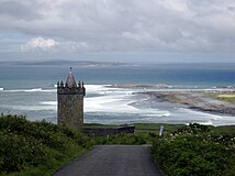 Doonagore Castle and the Aran Islands
 -
 Chamber of the court-cairn at Teergonean


References
Citations
Sources
- "Cill Aidhleach". Placenames Database of Ireland. Retrieved 2014-04-07.
- Frost, James (1897). "Corcomroe, Killilagh Parish". The History and Topography of the County of Clare. Retrieved 2014-04-07.
{{cite book}}: Invalid|ref=harv(help) - Lewis, Samuel. "Killeilagh". County Clare: A History and Topography 1837. Retrieved 2014-04-07.
{{cite book}}: Invalid|ref=harv(help) - "Map of Killilagh Parish showing Townlands". Clare County Library. Retrieved 2014-04-07.
- "Parish of Lisdoonvarna & Kilshanny". Diocese of Galway. Retrieved 2014-04-07.
- "Killilagh". Parliamentary Gazeteer of Ireland. 1845. Retrieved 2014-04-07.