
Líbeznice
Líbeznice | |
|---|---|
Municipality and village | |
 Old school in Líbeznice | |
 Flag  Coat of arms | |
 | |
| Country | |
| Region | Central Bohemian Region |
| District | Prague-East District |
| Area | |
| • Total | 1.69 sq mi (4.37 km2) |
| Elevation | 666 ft (203 m) |
| Population (2011) | |
| • Total | 1,522 |
| • Density | 900/sq mi (350/km2) |
| Time zone | UTC+1 (CET) |
| • Summer (DST) | UTC+2 (CEST) |

Líbeznice (in German Lübeznitz) is a village in the Central Bohemian Region of the Czech Republic. As of 1 January 2013, the village had 2000 inhabitants. The first written record of the village is in a document issued by the Bohemian king Wenceslaus I of Bohemia in 1236. The village is a member of the Povodí Mratínského potoka microregion.
Nationality
- Czech - 1430 citizens
- Ukrainian - 43 citizens
- Chilean - 3 citizens
- Slovakian - 22 citizens
- Vietnamese - 4 citizens
- Moravian - 2 citizens
- Bulgarian - 5 citizens
Gallery
-
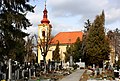 Church in Líbeznice
 -
 Old school house

External links
- Village website (cz)
50°11′44″N 14°29′57″E / 50.19556°N 14.49917°E
Wikimedia Commons has media related to Líbeznice.