Land use: Difference between revisions
m Reverted edits by 152.26.9.1 to last version by Elekhh (GLOO) |
|||
| Line 12: | Line 12: | ||
== Land use and the environment == |
== Land use and the environment == |
||
land use is the perfect thing to dowhile snaking on cheese. |
|||
Land use and land management practices have a major impact on [[natural resources]] including [[water]], [[soil]], [[nutrient]]s, [[plant]]s and [[animal]]s. Land use information can be used to develop solutions for natural resource management issues such as salinity and [[water quality]]. For instance, water bodies in a region that has been deforested or having erosion will have different water quality than those in areas that are [[forest]]ed. |
Land use and land management practices have a major impact on [[natural resources]] including [[water]], [[soil]], [[nutrient]]s, [[plant]]s and [[animal]]s. Land use information can be used to develop solutions for natural resource management issues such as salinity and [[water quality]]. For instance, water bodies in a region that has been deforested or having erosion will have different water quality than those in areas that are [[forest]]ed. |
||
Revision as of 14:13, 29 October 2010

- 'Land use' is also often used to refer to the distinct land use types in zoning.
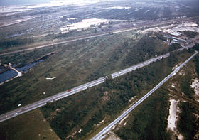
Land use is the human use of land. Land use involves the management and modification of natural environment or wilderness into built environment such as fields, pastures, and settlements. It has also been defined as "the arrangements, activities and inputs people undertake in a certain land cover type to produce, change or maintain it" (FAO, 1997a; FAO/UNEP, 1999). [1]
Land use and regulation
Land use practices vary considerably across the world. The United Nations' Food and Agriculture Organisation Water Development Division explains that "Land use concerns the products and/or benefits obtained from use of the land as well as the land management actions (activities) carried out by humans to produce those products and benefits." [2] As of the early 1990s, about 13% of the Earth was considered arable land, with 26% in pasture, 32% forests and woodland, and 1.5% urban areas.
As Albert Guttenberg (1959) wrote many years ago, "'Land use' is a key term in the language of city planning."[3] Commonly, political jurisdictions will undertake land use planning and regulate the use of land in an attempt to avoid land use conflicts. Land use plans are implemented through land division and use ordinances and regulations, such as zoning regulations.
Land use and the environment
land use is the perfect thing to dowhile snaking on cheese. Land use and land management practices have a major impact on natural resources including water, soil, nutrients, plants and animals. Land use information can be used to develop solutions for natural resource management issues such as salinity and water quality. For instance, water bodies in a region that has been deforested or having erosion will have different water quality than those in areas that are forested.
The major effect of land use on land cover since 1750 has been deforestation of temperate regions.[dead link][4] More recent significant effects of land use include urban sprawl, soil erosion, soil degradation, salinization, and desertification.[5] Land-use change, together with use of fossil fuels, are the major anthropogenic sources of carbon dioxide, a dominant greenhouse gas.[6]
According to a report by the United Nations' Food and Agriculture Organisation, land degradation has been exacerbated where there has been an absence of any land use planning, or of its orderly execution, or the existence of financial or legal incentives that have led to the wrong land use decisions, or one-sided central planning leading to over-utilization of the land resources - for instance for immediate production at all costs. As a consequence the result has often been misery for large segments of the local population and destruction of valuable ecosystems. Such narrow approaches should be replaced by a technique for the planning and management of land resources that is integrated and holistic and where land users are central. This will ensure the long-term quality of the land for human use, the prevention or resolution of social conflicts related to land use, and the conservation of ecosystems of high biodiversity value.
Urban growth boundaries
The urban growth boundary is one form of land-use regulation. For example, Portland, Oregon is required to have an urban growth boundary which contains at least 20,000 acres (81 km2) of vacant land. Additionally, Oregon restricts the development of farmland. The regulations are controversial, but an economic analysis concluded that farmland appreciated similarly to the other land.[7]
See also
References
- ^ IPCC Special Report on Land Use, Land-Use Change And Forestry, 2.2.1.1 Land Use
- ^ FAO Land and Water Division retrieved 14 September 2010
- ^ JAPA 25:3
- ^ [dead link]Intergovernmental Panel on Climate Change
- ^ UN Land Degradation and Land Use/Cover Data Sources ret. 26 June 2007
- ^ UN Report on Climate Change retrieved 25 June 2007 [from Web archive [1]
- ^ Jaeker WG, Plantinga AJ (2007). How have Land-use regulations Affected Property Values in Oregon? OSU Extension.
External links
- Guttenberg, Albert Z. 1959. 'A Multiple Land Use Classification System', Journal of the American Planning Association, 25: 3, 143 — 150
- Land use defined at Encyclopedia of Earth
- Land Use Law by Prof. Daniel R. Mandelker (Washington University in St. Louis School of Law)
- Land Use Accountability Project The Center for Public Integrity
- Schindler's Land Use Page (Michigan State University Extension Land Use Team)
- Land Policy Institute at Michigan State University
- Powell, W. Gabe. 2009. Identifying Land Use/Land Cover (LULC) Using National Agriculture Imagery Program (NAIP) Data as a Hydrologic Model Input for Local Flood Plain Management. Applied Research Project. Texas State University - San Marcos. http://ecommons.txstate.edu/arp/296/
- Attorney.org's Top Land Use Law Blogs

