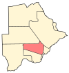
Letlhakeng
Letlhakeng | |
|---|---|
city | |
| Coordinates: 24°5′45″S 25°1′47″E / 24.09583°S 25.02972°E | |
| Country | Botswana |
| District | Kweneng District |
| Population (2001) | |
| • Total | 6,032 |
Letlhakeng or Lethakeng is an urban village in Kweneng District of Botswana. The village is located 75 km north-west of Molepolole. The population of Letlhakeng was 6,032 in the 2001 census.
The majority of the people of Letlhakeng are considered part of the Bakwena tribe, which is administered from the kgotla in Molepolole. However, aside from the Bakwena version of standard Setswana (known as Se-kwena), many people speak a version of Se-Kgalagadi - a language distinct from but related to Setswana.
Letlhakeng houses a secondary school (Mphuthe Community Secondary) which moved into new buildings in 2008 following relocation from a previous site prone to subsidence. A clinic serves the community as well as three primary schools and a number of local government offices. Until 2005, the tarred roads ended at the village centre and onward journeys were seasonally interrupted due to the gravel or sand roads. However, it is now possible to travel to most neighbouring villages without difficulty following a major road building programme.[1]
There are three schools in Letlhakeng being;
- Letlhakeng Primary School
- Gothibamang Primary School
- Mphuthe Junior Secondary School
See also
References
- ^ "Distribution of population by sex by villages and their associated localities: 2001 population and housing census". Archived from the original on 2007-11-24. Retrieved 2008-02-09.
24°5′45″S 25°1′47″E / 24.09583°S 25.02972°E


