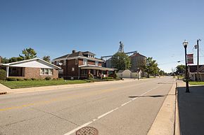
Milroy, Indiana
Appearance
Milroy, Indiana | |
|---|---|
 | |
 Location of Milroy in Rush County, Indiana. | |
| Coordinates: 39°29′49″N 85°28′11″W / 39.49694°N 85.46972°W | |
| Country | United States |
| State | Indiana |
| County | Rush |
| Township | Anderson |
| Area | |
| • Total | 0.66 sq mi (1.72 km2) |
| • Land | 0.66 sq mi (1.72 km2) |
| • Water | 0.00 sq mi (0.00 km2) |
| Elevation | 965 ft (294 m) |
| Population (2020) | |
| • Total | 628 |
| • Density | 948.64/sq mi (366.11/km2) |
| Time zone | UTC-5 (Eastern (EST)) |
| • Summer (DST) | UTC-4 (EDT) |
| ZIP code | 46156 |
| Area code | 765 |
| GNIS feature ID | 439254 |

Milroy is a census-designated place in Anderson Township, in the southern part of Rush County, in the U.S. state of Indiana.[3]
History
Milroy was laid out and platted in 1830.[4] The Milroy post office has been in operation since 1832.[5]
Education
The community contains Milroy Elementary School, a public school in the county school district.[6]
Geography
Milroy is located at 39°29′49″N 85°28′11″W / 39.49694°N 85.46972°W.
Demographics
| Census | Pop. | Note | %± |
|---|---|---|---|
| 2020 | 628 | — | |
| U.S. Decennial Census[7] | |||
References
- ^ "2020 U.S. Gazetteer Files". United States Census Bureau. Retrieved March 16, 2022.
- ^ "US Board on Geographic Names". United States Geological Survey. October 25, 2007. Retrieved 2016-11-17.
- ^ "Milroy, Indiana". Geographic Names Information System. United States Geological Survey, United States Department of the Interior. Retrieved 2017-02-25.
- ^ History of Rush County, Indiana: From the Earliest Time to the Present, with Biographical Sketches, Notes, Etc. Eastern Indiana Publishing Company. 1888. p. 661.
- ^ "Rush County". Jim Forte Postal History. Retrieved February 25, 2017.
- ^ "Milroy Elementary School". Rush County Schools. Retrieved 1 December 2015.
- ^ "Census of Population and Housing". Census.gov. Retrieved June 4, 2016.
External links

