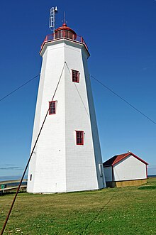
Miscou Island Lighthouse
 Miscou Island Lighthouse | |
 | |
| Location | North-East Tip of Miscou Island North-East terminus of Route 113 Gloucester County New Brunswick Canada |
|---|---|
| Coordinates | 48°00′32″N 64°29′28″W / 48.009°N 64.491°W |
| Tower | |
| Constructed | 1856 (first) |
| Construction | wooden tower |
| Height | 11.3 metres (37 ft) |
| Shape | octagonal prism tower with balcony and lantern |
| Markings | white tower and gallery, red lantern and trim |
| Operator | Développement Touristique de Miscou[1] |
| Heritage | recognized federal heritage building of Canada, national Historic Sites of Canada, provincial heritage place |
| Light | |
| First lit | 1930s (current) |
| Focal height | 14 metres (46 ft) |
| Characteristic | Fl G 5s. |
Miscou Island Lighthouse is an 11-metre (36 ft)-tall landfall lighthouse located on the North-Eastern tip of Miscou Island, at the entrance of the Chaleur Bay. It was built in 1856 and currently in use by the Canadian Coast Guard who owns the lighthouse, the land it is on, and also maintains it.[2]
The light's characteristic is a single green flash that occurs every five seconds, emitted at a focal plane height of 14 metres (46 ft).
See also
References
- ^ Rowlett, Russ. "Lighthouses of Canada: Southern New Brunswick". The Lighthouse Directory. University of North Carolina at Chapel Hill. Retrieved December 28, 2015.
- ^ http://www.tourismnewbrunswick.ca/Products/M/Miscou-Island-Lighthouse.aspx
Wikimedia Commons has media related to Miscou Island Lighthouse.
