
Munbilla, Queensland
| Munbilla Queensland | |||||||||||||||
|---|---|---|---|---|---|---|---|---|---|---|---|---|---|---|---|
 Farm on Kengoon Road, 2015 | |||||||||||||||
 Munbilla | |||||||||||||||
| Coordinates | 27°52′31″S 152°39′35″E / 27.8752°S 152.6597°E | ||||||||||||||
| Population | 100 (2016 census)[1] | ||||||||||||||
| • Density | 9/km2 (23/sq mi) | ||||||||||||||
| Postcode(s) | 4309 | ||||||||||||||
| Area | 11.4 km2 (4.4 sq mi) | ||||||||||||||
| Time zone | AEST (UTC+10:00) | ||||||||||||||
| Location |
| ||||||||||||||
| LGA(s) | Scenic Rim Region | ||||||||||||||
| State electorate(s) | Scenic Rim | ||||||||||||||
| Federal division(s) | Wright | ||||||||||||||
| |||||||||||||||
Munbilla is a rural town and locality in the Scenic Rim Region, Queensland, Australia.[2][3] In the 2016 census, the locality of Munbilla had a population of 100 people.[1]
Geography[edit]
Warrill Creek forms the north-western boundary of the locality.[4] The town is in the north-east of the locality.[5]
Mooroo Ougee Lagoon is a perennial waterhole in the north of the locality (27°52′01″S 152°38′51″E / 27.8669°S 152.6475°E).[6]
History[edit]
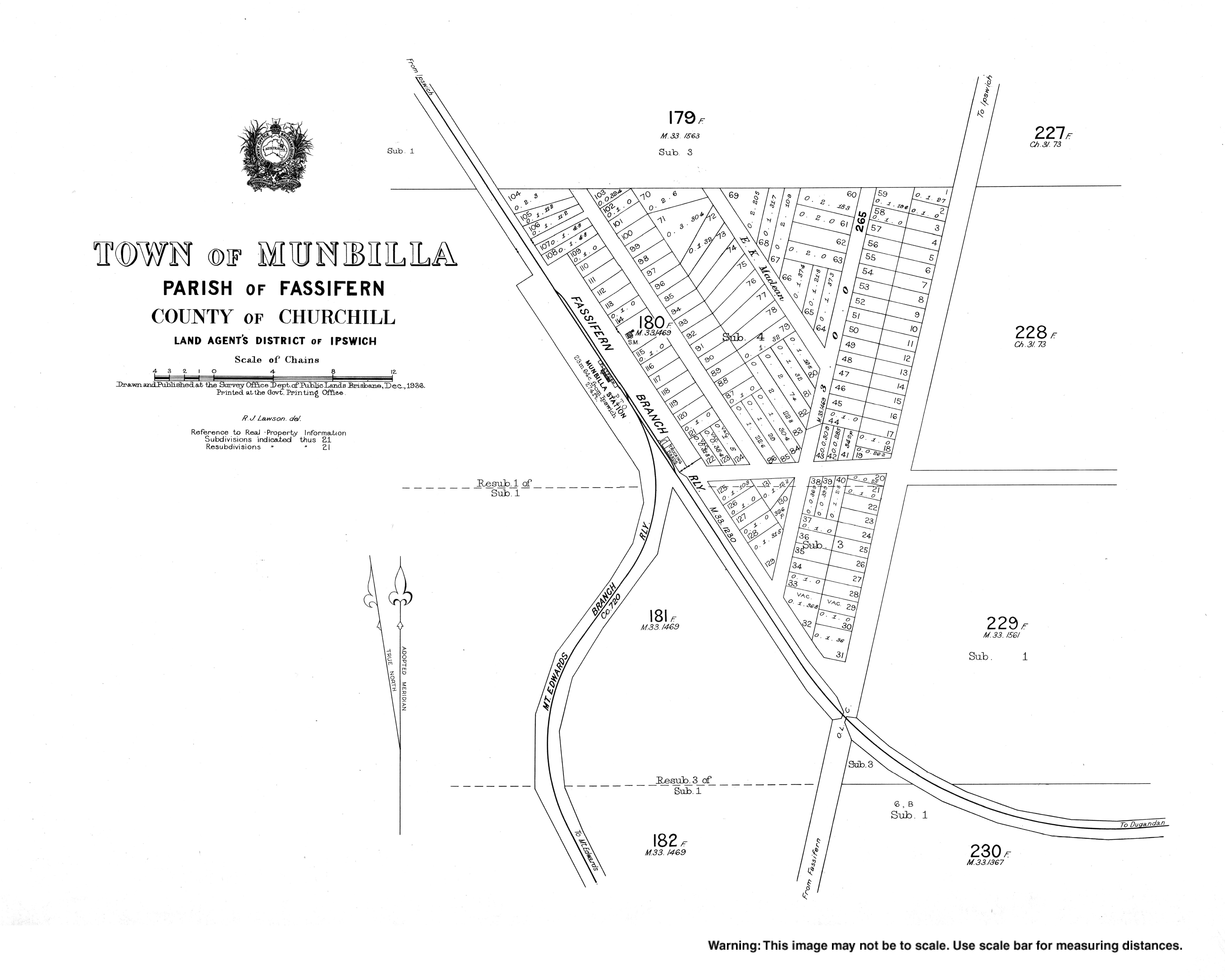
The suburb takes its name from the former Munbilla railway station, whose name was created in 1886 by the Queensland Railways Department using the Yuggera words mun (meaning much) and billa (meaning water) to mean a large lagoon.[2]
The Fassifern railway line (Queensland's first branch railway line) opened from Ipswich to Harrisville on 10 July 1882. On 12 September 1887 the line was extended to Dugundan with Munbilla being served by Munbilla railway station on Macfarlane Road (27°52′16″S 152°39′22″E / 27.8711°S 152.6561°E). The line closed in June 1964.[7][8]
The Mount Edwards branch line branched off from the Fassifern line immediately south of the Munbilla railway station (27°52′17″S 152°39′23″E / 27.8714°S 152.6563°E). The Mount Edwards line opened to Kalbar on 17 April 1916 and to Mount Edwards on 7 October 1922. The Mount Edwards line closed in 1960.[9][10]
At the 2011 census, the locality and surrounds recorded a population of 434.[11]
In the 2016 census, the locality of Munbilla had a population of 100 people.[1]
Education[edit]
There are no schools in Munbilla. The nearest government primary schools are:[5]
- Harrisville State School in Harrisville to the north
- Roadvale State School in Roadvale to the south-east
- Kalbar State School in Kalbar to the south
- Warrill View State School in Warrill View to the north-west
The nearest government secondary school is Boonah State High School in Boonah to the south.[5]
References[edit]
- ^ a b c Australian Bureau of Statistics (27 June 2017). "Munbilla (SSC)". 2016 Census QuickStats. Retrieved 20 October 2018.
- ^ a b "Munbilla – town in Scenic Rim Region (entry 23412)". Queensland Place Names. Queensland Government. Retrieved 30 November 2019.
- ^ "Munbilla – locality in Scenic Rim Region (entry 45175)". Queensland Place Names. Queensland Government. Retrieved 30 November 2019.
- ^ Google (15 September 2021). "Munbilla, Queensland" (Map). Google Maps. Google. Retrieved 15 September 2021.
- ^ a b c "Queensland Globe". State of Queensland. Retrieved 15 November 2022.
- ^ "Mooroo Ougee Lagoon – waterhole in Scenic Rim Regional (entry 22740)". Queensland Place Names. Queensland Government. Retrieved 14 August 2022.
- ^ Kerr, John (1990). Triumph of narrow gauge : a history of Queensland Railways. Boolarong Publications. pp. 57–58, 224. ISBN 978-0-86439-102-5.
- ^ "Flinders" (Map). Queensland Government. 1927. Archived from the original on 29 May 2020. Retrieved 29 May 2020.
- ^ QR Limited. "Rail as foremost mode of travel". Archived from the original on 12 September 2009. Retrieved 25 October 2009.
- ^ Southern Downs Steam Railway (2009). "'Via recta' - The line that never was". Archived from the original on 12 September 2009. Retrieved 25 October 2009.
- ^ Australian Bureau of Statistics (31 October 2012). "Munbilla (State Suburb)". 2011 Census QuickStats. Retrieved 9 April 2015.