
Neuried, Bavaria
Neuried | |
|---|---|
_St._Nikolaus_229.jpg) Church of Saint Nicholas | |
 Coat of arms | |
Location of Neuried within Munich district 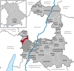 | |
 Neuried  Neuried | |
| Coordinates: 48°5′36″N 11°27′57″E / 48.09333°N 11.46583°E | |
| Country | Germany |
| State | Bavaria |
| Admin. region | Oberbayern |
| District | Munich |
| Government | |
| • Mayor (2020–26) | Harald Zipfel[1] (SPD) |
| Area | |
| • Total | 9.63 km2 (3.72 sq mi) |
| Elevation | 559 m (1,834 ft) |
| Population (2022-12-31)[2] | |
| • Total | 8,967 |
| • Density | 930/km2 (2,400/sq mi) |
| Time zone | UTC+01:00 (CET) |
| • Summer (DST) | UTC+02:00 (CEST) |
| Postal codes | 82061 |
| Dialling codes | 089 |
| Vehicle registration | M |
| Website | www.neuried.de |
Neuried is a municipality in the district of Munich in Bavaria in Germany.
References[edit]
- ^ Liste der ersten Bürgermeister/Oberbürgermeister in kreisangehörigen Gemeinden, Bayerisches Landesamt für Statistik, 15 July 2021.
- ^ Genesis Online-Datenbank des Bayerischen Landesamtes für Statistik Tabelle 12411-003r Fortschreibung des Bevölkerungsstandes: Gemeinden, Stichtag (Einwohnerzahlen auf Grundlage des Zensus 2011) (Hilfe dazu).
| International | |
|---|---|
| National | |
This Munich district location article is a stub. You can help Wikipedia by expanding it. |