
Osakai
This article has multiple issues. Please help improve it or discuss these issues on the talk page. (Learn how and when to remove these template messages)
|
Osakai | |
|---|---|
Village | |
 Osakai  Osakai | |
| Coordinates: 34°43′N 71°58′E / 34.71°N 71.97°E | |
| Pakistan | |
| Province | Khyber Pakhtunkhwa |
| District | Lower Dir |
| Tehsil | Adenzai |
| Time zone | PST |
Osakai is a village in Lower Dir District of the Khyber Pakhtunkhwa province of Pakistan. Osakai is divided into Osakai Bala and Osakai Payeen. It comes under Union Council Kotigram and under Tehsil Adenzai. Osakai as a whole consists of Karimabad, Dagai, Ghwandai, Qazi Abad and Lowarha. Osakai has a hospital unit, a government high school for girls and also a government high school for boys. Osakai has some historical places (e.g., Kafar Kot, now adays known as Muslim kot, Sroo Manroo (Red Fort), Shah Goo and also many picnic spots (e.g., Osakai waterfall, Khan Baba, Bar Charhay, and small water dams). Due to availability of almost all basic facilities many peoples from Lower Dir and Upper Dir and some ather district have started migration to this village. Large numbers of migrated families now reside in Kas and Kafar Kot, now known as Muslim kot. Osakai also has a quarry where stone slabs for graves are extracted. They can also be used for sewage systems.
Tribes in Osakai include Sarkani Khail, Roghani, Uthman Khail, Tajak, Degaan, Shinwari, Sadaat, Wardag, and Babakhail.
Gallery[edit]
-
 Osakai
 -
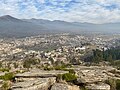
 Osakai mountain
 -
 Road to Osakai Mountains


Occupation: The people of this village are doing business in Punjab,KPK and Sindh provinces and some people are working in Saudi Arabia. Small ratio of the population are farmers and labors.