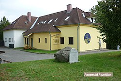
Panenská Rozsíčka
Appearance
(Redirected from Panenska Rozsicka)
Panenská Rozsíčka | |
|---|---|
 Guesthouse | |
| Coordinates: 49°15′9″N 15°30′54″E / 49.25250°N 15.51500°E | |
| Country | |
| Region | Vysočina |
| District | Jihlava |
| First mentioned | 1351 |
| Area | |
| • Total | 4.41 km2 (1.70 sq mi) |
| Elevation | 607 m (1,991 ft) |
| Population (2024-01-01)[1] | |
| • Total | 245 |
| • Density | 56/km2 (140/sq mi) |
| Time zone | UTC+1 (CET) |
| • Summer (DST) | UTC+2 (CEST) |
| Postal code | 589 01 |
| Website | panenskarozsicka |
Panenská Rozsíčka (Czech pronunciation: [ˈpanɛnskaː ˈros.siːtʃka]) is a municipality and village in Jihlava District in the Vysočina Region of the Czech Republic. It has about 200 inhabitants.
Geography
[edit]Panenská Rozsíčka is located about 17 kilometres (11 mi) south of Jihlava. It lies in the Křižanov Highlands. The highest point is the Hřeben hill at 678 m (2,224 ft) above sea level. The Moravian Thaya River originates in the northern part of the municipal territory, then flows along the eastern municipal border.
History
[edit]The first written mention of Panenská Rozsíčka is from 1351.[2]
Demographics
[edit]
|
|
| ||||||||||||||||||||||||||||||||||||||||||||||||||||||
| Source: Censuses[3][4] | ||||||||||||||||||||||||||||||||||||||||||||||||||||||||
Transport
[edit]There are no railways or major roads passing through the municipality.
Sights
[edit]There are no protected cultural monuments in the municipality.[5]
References
[edit]- ^ "Population of Municipalities – 1 January 2024". Czech Statistical Office. 2024-05-17.
- ^ "Základní informace o obci" (in Czech). Obec Panenská Rozsíčka. Retrieved 2023-09-20.
- ^ "Historický lexikon obcí České republiky 1869–2011" (in Czech). Czech Statistical Office. 2015-12-21.
- ^ "Population Census 2021: Population by sex". Public Database. Czech Statistical Office. 2021-03-27.
- ^ "Výsledky vyhledávání: Kulturní památky, obec Panenská Rozsíčka". Ústřední seznam kulturních památek (in Czech). National Heritage Institute. Retrieved 2024-08-26.
External links
[edit]Wikimedia Commons has media related to Panenská Rozsíčka.


