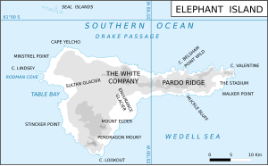
Pardo Ridge
Appearance

Pardo Ridge is the highest part of Elephant Island, South Shetland Islands, reaching an altitude of 852 m. It extends from The White Company in the West to Cape Valentine in the East. It was mapped by the UK Joint Services Expedition, 1970-71, and named by the UK-APC after Captain Luis Pardo, commander of the Chilean tug Yelcho which rescued shipwrecked members of Shackleton's Endurance from Elephant Island's Wild Point in August 1916.[citation needed]
See also
61°07′30″S 54°53′00″W / 61.12500°S 54.88333°W
