Parkersburg–Belpre Bridge
Parkersburg–Belpre Bridge | |
|---|---|
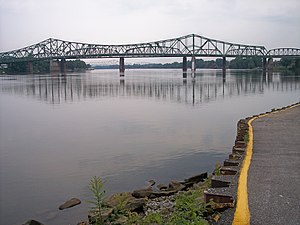
 The Parkersburg-Belpre Bridge (foreground), the Parkersburg CSX Bridge, and the Memorial Bridge in 2006 | |
| Coordinates | 39°16′15″N 81°33′58″W / 39.270919°N 81.566191°W |
| Carries | |
| Crosses | Ohio River |
| Locale | Parkersburg, West Virginia |
| Owner | West Virginia Division of Highways |
| Characteristics | |
| No. of lanes | 4 |
| History | |
| Opened | 1980 |
| Replaces | Parkersburg Suspension Bridge |
| Location | |
 | |
The Parkersburg–Belpre Bridge is a four-lane cantilever bridge that connects Parkersburg, West Virginia to Belpre, Ohio across the Ohio River. The bridge was completed in 1980. The bridge had been signed U.S. Route 50 (US 50) until June 13, 2008, when that highway was re-routed to the Blennerhassett Island Bridge a few miles to the west, as part of the completion of the Corridor D project around Parkersburg. The American Discovery Trail uses the bridge to cross the Ohio River.[1]
Parkersburg Suspension Bridge
The current bridge replaced a 1916 suspension bridge located just downstream of the present site. The bridge was designed by Hermann Lamb and built by the John A. Roebling's Sons Company of New Jersey.[2] The bridge had a 22-foot-wide (6.7 m) deck, which included a pedestrian walkway. The main span was 775 feet (236 m) and the side spans were 275 feet (84 m) and 375 feet (114 m). The suspension bridge was demolished on March 16, 1980.[3]
See also
- List of bridges documented by the Historic American Engineering Record in Ohio
- List of bridges documented by the Historic American Engineering Record in West Virginia
- List of crossings of the Ohio River
References
- ^ "American Discovery Trail in Ohio". discoverytrail.org. Retrieved 2019-04-01.
- ^ "Parkersburg Suspension Bridge". Structurae.de. Retrieved 2009-01-27.
- ^ "Suspension Bridges 1900-1924 (1-100 of 204)". Bridgemeister.
External links
- Parkersburg-Belpre Bridge at Bridges & Tunnels
- Photograph of the early stages of construction of the current bridge, December 1976
- Photograph of the partial dismantling of the 1916 suspension bridge, February 1980
- Description and photographs of the controlled explosive demolition of the 1916 suspension bridge, March 16, 1980, from Controlled Demolition, Inc.
- Historic American Engineering Record (HAER) No. WV-88, "Parkersburg Suspension Bridge, Spanning Ohio River between Parkersburg, WV, and Belpre, OH", 1 photo, 1 photo caption page
- Parkersburg Suspension Bridge at Structurae
- Parkersburg-Belpre Bridge at Structurae
- Bridges completed in 1980
- Bridges over the Ohio River
- Bridges in Washington County, Ohio
- Buildings and structures in Parkersburg, West Virginia
- Cantilever bridges in the United States
- Historic American Engineering Record in Ohio
- Historic American Engineering Record in West Virginia
- Road bridges in Ohio
- Road bridges in West Virginia
- Transportation in Wood County, West Virginia
- U.S. Route 50
- Truss bridges in the United States
- 1980 establishments in West Virginia
- 1980 establishments in Ohio
- Interstate vehicle bridges in the United States
- Midwestern United States bridge (structure) stubs
- Ohio building and structure stubs
- Ohio transportation stubs
- Southern United States bridge (structure) stubs
- West Virginia building and structure stubs
- West Virginia transportation stubs

