
Plesio
Plesio
Pies (Lombard) | |
|---|---|
| Comune di Plesio | |
Location of Plesio  | |
 Plesio Location of Plesio in Italy  Plesio Plesio (Lombardy) | |
| Coordinates: 46°3′N 9°14′E / 46.050°N 9.233°E | |
| Country | Italy |
| Region | Lombardy |
| Province | Province of Como (CO) |
| Area | |
| • Total | 17.0 km2 (6.6 sq mi) |
| Population (Dec. 2004)[2] | |
| • Total | 833 |
| • Density | 49/km2 (130/sq mi) |
| Time zone | UTC+1 (CET) |
| • Summer (DST) | UTC+2 (CEST) |
| Postal code | 22010 |
| Dialing code | 0344 |
Plesio (Comasco: Pies [ˈpjeːs]) is a comune (municipality) in the Province of Como in the Italian region Lombardy, located about 70 kilometres (43 mi) north of Milan and about 30 kilometres (19 mi) northeast of Como. As of 31 December 2004, it had a population of 833 and an area of 17.0 square kilometres (6.6 sq mi).[3]
Plesio borders the following municipalities: Cremia, Garzeno, Grandola ed Uniti, Menaggio, San Siro.
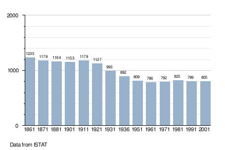
Demographic evolution
References
- ^ "Superficie di Comuni Province e Regioni italiane al 9 ottobre 2011". Italian National Institute of Statistics. Retrieved 16 March 2019.
- ^ "Popolazione Residente al 1° Gennaio 2018". Italian National Institute of Statistics. Retrieved 16 March 2019.
- ^ All demographics and other statistics: Italian statistical institute Istat.
This article on a location in the Province of Como is a stub. You can help Wikipedia by expanding it. |