Plánice
Appearance
Plánice | |
|---|---|
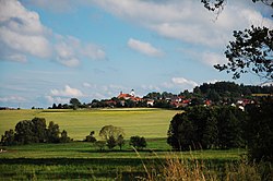
 Panorama of Plánice | |
| Coordinates: 49°23′22″N 13°28′29″E / 49.38944°N 13.47472°E | |
| Country | |
| Region | Plzeň |
| District | Klatovy |
| First mentioned | 1352 |
| Government | |
| • Mayor | Zdeněk Pavlíček |
| Area | |
| • Total | 55.64 km2 (21.48 sq mi) |
| Elevation | 579 m (1,900 ft) |
| Population (2021-01-01)[1] | |
| • Total | 1,660 |
| • Density | 30/km2 (77/sq mi) |
| Time zone | UTC+1 (CET) |
| • Summer (DST) | UTC+2 (CEST) |
| Postal codes | 339 01, 340 34, 341 01, 341 42 |
| Website | www |
Plánice (Czech pronunciation: [ˈplaːɲɪtsɛ]) (German: Planitz) is a town in Klatovy District in the Plzeň Region of the Czech Republic. It has about 1,700 inhabitants. It lies some 40 km (25 mi) to the south from the region capital of Plzeň.
Administrative parts
Villages of Bližanovy, Křížovice, Kvasetice, Lovčice, Mlynářovice, Nová Plánice, Pohoří, Štipoklasy, Vracov, Zbyslav and Zdebořice are administrative parts of Plánice.
Notable people
- František Křižík (1847–1941), engineer and inventor
Twin towns – sister cities
 Rubigen, Switzerland
References
- ^ "Population of Municipalities – 1 January 2021". Czech Statistical Office. 2021-04-30.
- ^ "Plánice – kostel sv. Blažeje". masposumavi.cz (in Czech). Místní akční skupina Pošumaví. Retrieved 2020-07-27.
External links
Wikimedia Commons has media related to Plánice.


