Pohjois-Tapiola
Appearance
Pohjois-Tapiola
Norra Hagalund | |
|---|---|
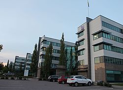
 Buildings of Spektri, a business park in Pohjois-Tapiola | |
 Location of Pohjois-Tapiola (red) within Espoo (light green) and Suur-Tapiola (dark green) | |
| Coordinates: 60°11′45″N 24°47′30″E / 60.19583°N 24.79167°E | |
| Country | |
| Region | |
| Sub-region | Greater Helsinki |
| Municipality | |
| Main District | Suur-Tapiola |
| Area | |
• Total | 2.2 km2 (0.8 sq mi) |
| Population (2006) | |
• Total | 6,035 |
| • Density | 2,700/km2 (7,100/sq mi) |
| Languages | |
| • Finnish | 91.8 % |
| • Swedish | 5.3 % |
| • Other | 2.9 % |
| Postal Code(s) | 02130 |
| Jobs | 2,513 |
Pohjois-Tapiola (Template:Lang-sv) is a district of the municipality of Espoo, Finland.[1][2]
See also
References
- ^ "Pohjois-Tapiola | Espoon Asunnot". www.espoonasunnot.fi. Retrieved 2022-10-14.
- ^ Teivainen, Aleksi (2015-12-16). "Parliament agrees to lift restrictions on shop opening hours". Helsinki Times. Retrieved 2022-10-14.

