Pokkinen
Appearance
Pokkinen | |
|---|---|
District of Oulu | |
 | |
 | |
| Country | Finland |
| City | Oulu |
| Areas of Oulu | City Centre |
| Population (2013)[1] | |
• Total | 2 333 |
| Postal code | 90100 |
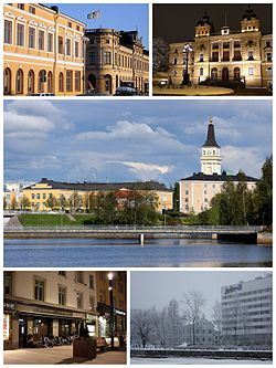
Pokkinen is a district of the city centre area of Oulu, Finland. Together with districts of Vaara and Vanhatulli, Pokkinen forms the central business district of Oulu. It is bounded by the estuary of the Oulujoki river to the west, the Koskikeskus and Myllytulli districts to the north, the Vaara district to the east and the Vanhatulli district to the south.[2]
Pokkinen is the oldest part of Oulu. The city hall, Oulu Cathedral, the market square and other cultural and municipal institutions are located in the district.
References
[edit]- ^ "Oulun kaupungin ikäluokkatilasto kaupunginosittain 1.1.2013" (pdf). City of Oulu. 2013. Retrieved July 12, 2013.
- ^ Oulun suuralue- ja kaupunginosajako 1.1.2013 alkaen [Subdivisions of the City of Oulu on Jan 1, 2013] (pdf) (Map). City of Oulu. 2013. Retrieved 2013-08-07.
External links
[edit]![]() Media related to Pokkinen at Wikimedia Commons
Media related to Pokkinen at Wikimedia Commons
