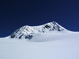
Rainerhorn
Appearance
| Rainerhorn | |
|---|---|
 Summit from the south | |
| Highest point | |
| Elevation | 3,559 m (11,677 ft) |
| Coordinates | 47°6′7″N 12°21′47″E / 47.10194°N 12.36306°E |
| Geography | |
| Location | Tyrol, Austria |
| Parent range | Hohe Tauern |
| Climbing | |
| First ascent | 10 August 1859 by Franz Keil and Ignaz Wagl |
The Rainerhorn (German: [ˈʁaɪnɐˌhɔɐ̯n] ) is a mountain in the Venediger Group. It is 3,559 m (11,677 ft) high.
References
- Willi End: Alpenvereinsführer Venedigergruppe, Munich 2006, ISBN 3-7633-1242-0
- Eduard Richter, Hrsg.: Erschließung der Ostalpen, III. Band, Verlag des Deutschen und Oesterreichischen Alpenvereins, Berlin 1894
- Alpenvereinskarte 1:25.000, Sheet 36, Venedigergruppe

