
Ringstead Bay


Ringstead Bay and the small village of Ringstead are located on the coast in Dorset, southern England. The area lies on the Jurassic Coast and is known for its natural beauty and fossils.
Ringstead Bay has a pebble and shingle beach with some sand. There are offshore reefs approximately 600 metres in length at the western end opposite the village that are uncovered at low tide. This forms is intertidal zone between the low cliffs to the north and the English Channel to the south.
The original medieval village and church at Ringstead, located in a field to the east of the current settlement and mentioned in the Domesday Book, no longer exists. It was most likely abandoned after the arrival of the Black Death at Weymouth in 1348.[1]
Immediately to the east are the white chalk cliffs of White Nothe, dominating the bay. It is possible to walk to the top of White Nothe and back, with spectacular views of the bay and across to the Isle of Portland.[2] It is also possible to walk to Ringstead Bay on a circular walk from Lulworth Cove to the east, via Durdle Door and White Nothe.[3]
The small village of Osmington Mills lies on the coast about 1.5 km to the west and there is a footpath along the cliffs, via Bran Point.[4][5] Perry Ledge is a reef off the beach near Bran Point. The large town of Weymouth is situated approximately 8 km west of Ringstead Bay.
Ringstead also has a nudist beach that is a 20-minutes walk east of the main beach.[6]
Access
Ringstead Bay is accessible by way of a private road with a car park at the end near the sea. There is an alternative free car park in the National Trust area further inland, with footpath access to the sea via a 15–20 minute walk.
Gallery
-
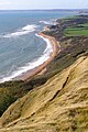 View west across Ringstead Bay
 -
 View across Ringstead Bay to White Nothe
 -
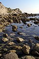 Rocky foreshore on the east side of Ringstead Bay
 -
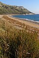
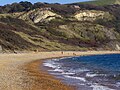 Beach and cliffs, Ringstead Bay
 -
 View of the Isle of Portland from Ringstead Bay
 -
 View of the Isle of Portland from Ringstead Bay


See also
References
- ^ "Ringstead". www.jurassiccoastline.com. Jurassic Coastline. Retrieved 10 November 2013.
- ^ West, Ian. "Ringstead Bay to White Nothe, Dorset". Geology of the Wessex Coast of Southern England. UK: University of Southampton. Retrieved 10 November 2013.
- ^ Durdle Door & White Nothe circular, The South West Coast Path National Trail, UK.
- ^ West, Ian. "Osmington Mills to Ringstead Bay — Corallian Strata". Geology of the Wessex Coast of Southern England. UK: University of Southampton. Retrieved 10 November 2013.
- ^ Osmington, Osmington Mills and Ringstead, Dorset, UK.
- ^ "Ringstead Bay news from the Dorset Beaches". dorsetbeaches.co.uk. Archived from the original on 2015-05-26. Retrieved 2015-08-16.
External links
- Map sources for Ringstead Bay