Rusinowo, Rypin County
Appearance
Rusinowo | |
|---|---|
Village | |
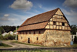
 Granarie shed in Rusinowo | |
| Coordinates: 53°05′21″N 19°23′19″E / 53.08917°N 19.38861°E | |
| Country | |
| Voivodeship | Kuyavian-Pomeranian |
| County | Rypin |
| Gmina | Gmina Rypin |
| Time zone | UTC+1 (CET) |
| • Summer (DST) | UTC+2 (CEST) |
| Vehicle registration | CRY |
Rusinowo [ruɕiˈnɔvɔ] (German: Rauschenfeld) is a village in the administrative district of Gmina Rypin, within Rypin County, Kuyavian-Pomeranian Voivodeship, in north-central Poland.[1]
History

During the German occupation of Poland (World War II), Rusinowo was the site of a massacre of around 200 Poles from the nearby town of Rypin and the Rypin County, carried out by Germany as part of the genocidal Intelligenzaktion.[2] In 1942, the occupiers also carried out expulsions of Poles, whose farms were then handed over to Germans as part of the Lebensraum policy.[3]
References
- ^ "Central Statistical Office (GUS) – TERYT (National Register of Territorial Land Apportionment Journal)" (in Polish). 2008-06-01.
- ^ Wardzyńska, Maria (2009). Był rok 1939. Operacja niemieckiej policji bezpieczeństwa w Polsce. Intelligenzaktion (in Polish). Warszawa: IPN. p. 175.
- ^ Wardzyńska, Maria (2017). Wysiedlenia ludności polskiej z okupowanych ziem polskich włączonych do III Rzeszy w latach 1939-1945 (in Polish). Warszawa: IPN. p. 124. ISBN 978-83-8098-174-4.


