Saltford Lock

Coordinates: 51°24′35″N 2°26′35″W / 51.40966°N 2.44314°W / 51.40966; -2.44314
From Wikipedia, the free encyclopedia

This is an old revision of this page, as edited by Ebyabe (talk | contribs) at 16:33, 29 November 2011 (→‎See also: refine category, replaced: Category:17 → Category:Buildings and structures completed in 17, 7 architecture]] → 7]] using AWB). The present address (URL) is a permanent link to this revision, which may differ significantly from the current revision.

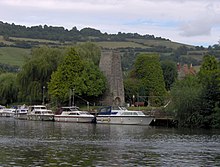
Looking across water to moored boats. Beyond them is a stone chimney surrounded by trees, with hills in the distance.
Kelston Brass Mill overlooking Saltford lock

Saltford Lock (grid reference ST692679) is situated on the River Avon, at the village of Saltford, between Bristol and Bath, England.

The lock and weir are overlooked by the remains of the Kelston Brass Mill, which was working until 1925. It is a grade II listed building.[1] Alongside the lock is a pub, whose garden extends over the lock to the small island between the lock and weir. The lock was opened in 1727 and destroyed in 1738 by rival coal dealers to stop the use of the river for transportation.[2]

References

  1. ^ "Remains of 2 Annealing Ovens". Images of England. Retrieved 2006-09-24.
  2. ^ Allsop, Niall (1987). The Kennet & Avon Canal. Bath: Millstream Book. ISBN 0-948975-15-6.

See also

Next lock upstream River Avon, Bristol / Kennet and Avon Canal Next lock downstream
Kelston Lock Saltford Lock
Grid reference: ST692679
Swineford Lock

51°24′35″N 2°26′35″W / 51.40966°N 2.44314°W / 51.40966; -2.44314