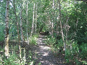
Sheriffhall railway station
Sheriffhall | |
|---|---|
 The site of the station in 2005 | |
| General information | |
| Location | Sheriffhall, Midlothian Scotland |
| Coordinates | 55°53′54″N 3°05′12″W / 55.898293°N 3.086699°W |
| Grid reference | NT321677 |
| Platforms | 1 |
| Other information | |
| Status | Disused |
| History | |
| Original company | Edinburgh and Dalkeith Railway North British Railway |
| Key dates | |
| March 1844 | Opened |
| 1849 | Closed |
Sheriffhall railway station served the village of Sheriffhall, Dalkeith, Scotland, from 1844 to 1849 on the Waverley Route.
History[edit]
The station was opened in March 1844 by the Edinburgh and Dalkeith Railway.[1] The station may have opened before, but information on the intermediate timetable was very vague.[2] The station was situated between the A68 bridge and Sheriffhall. The station had a very short lifespan; it was only open for 5 years and it closed down once the North British Railway had taken over the line.
The site today[edit]
The rebuilt section of the A6106 between Millerhill and Sheriffhall was opened on 30 March 2015, which means that a new railway, called the Borders Railway, can be opened parallel to the section of the road. The Borders Railway involves 30 miles of a new track with ten stops, 7 being new stations.[3]
References[edit]
- ^ Quick, M E (2002). Railway passenger stations in England, Scotland and Wales - a chronology. Richmond: Railway and Canal Historical Society. p. 363. OCLC 931112387.
- ^ "Disused Stations - Sheriffhall". Disused Stations. Retrieved 6 February 2017.
- ^ "REBUILT A6106 BETWEEN MILLERHILL & SHERIFFHALL OPENS". Borders Railway. Retrieved 6 February 2017.
External links[edit]
| Preceding station | Historical railways | Following station | ||
|---|---|---|---|---|
| Millerhill Line closed, station closed |
North British Railway Edinburgh and Dalkeith Railway |
Dalkeith Line partly open, station closed | ||
