Solomiac
Appearance
Solomiac | |
|---|---|
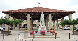
 War memorial and market hall | |
| Coordinates: 43°48′23″N 0°53′54″E / 43.8064°N 0.8983°E | |
| Country | France |
| Region | Occitania |
| Department | Gers |
| Arrondissement | Condom |
| Canton | Gimone-Arrats |
| Government | |
| • Mayor (2020–2026) | Guy Mantovani[1] |
| Area 1 | 13.8 km2 (5.3 sq mi) |
| Population (2021)[2] | 493 |
| • Density | 36/km2 (93/sq mi) |
| Time zone | UTC+01:00 (CET) |
| • Summer (DST) | UTC+02:00 (CEST) |
| INSEE/Postal code | 32436 /32120 |
| Elevation | 115–202 m (377–663 ft) (avg. 113 m or 371 ft) |
| 1 French Land Register data, which excludes lakes, ponds, glaciers > 1 km2 (0.386 sq mi or 247 acres) and river estuaries. | |
Solomiac (French pronunciation: [sɔlɔmjak]) is a commune in the Gers department in southwestern France.
Geography

History
Solomiac was founded in 1322, by the Planselve Abbey, the Cistercian monastery, which was active from 1143 until 1789 and Beraud, the Seneschal of Solomiac.
Structure
This Bastide has the typical central market square with the halle, the market building in the center of this open space. The market building is built with stone with wooden and stone pillars on the roof. Around this area there are the typical stone houses with the arcades. At the top of the square, where is a church.
Population
| Year | Pop. | ±% |
|---|---|---|
| 1962 | 519 | — |
| 1968 | 505 | −2.7% |
| 1975 | 446 | −11.7% |
| 1982 | 391 | −12.3% |
| 1990 | 363 | −7.2% |
| 1999 | 364 | +0.3% |
| 2008 | 418 | +14.8% |
See also
- Communes of the Gers department
- "Select Solomiac, at All Bastides". John Reps Collection. Cornell University Library.
References
- ^ "Répertoire national des élus: les maires". data.gouv.fr, Plateforme ouverte des données publiques françaises (in French). 2 December 2020.
- ^ "Populations légales 2021" (in French). The National Institute of Statistics and Economic Studies. 28 December 2023.
Wikimedia Commons has media related to Solomiac.


