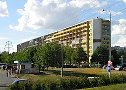
Střížkov
Appearance
Střížkov | |
|---|---|
 Prosek housing estate | |
 Location of Střížkov in Prague | |
| Coordinates: 50°07′40″N 14°29′26″E / 50.12778°N 14.49056°E | |
| Country | Czech Republic |
| Region | Prague |
| District | Prague 8, Prague 9 |
| Area | |
• Total | 2.03 km2 (0.78 sq mi) |
| Population (2021)[1] | |
• Total | 15,705 |
| • Density | 7,700/km2 (20,000/sq mi) |
| Time zone | UTC+1 (CET) |
| • Summer (DST) | UTC+2 (CEST) |
Střížkov (German: Strischkau) is a cadastral area of Prague, Czech Republic, divided between the districts of Prague 8 and Prague 9. Střížkov has 15,705 inhabitants as of 2021.[2]
Demographics
[edit]
|
| |||||||||||||||||||||||||||||||||||||||||||||||||||
| Source: Censuses[3][1] | ||||||||||||||||||||||||||||||||||||||||||||||||||||
Transport
[edit]Střížkov station on the Prague Metro's Line C serves the district. There are also several buses coming through the area.
Sport
[edit]The district was home to an association football club, FK Bohemians Prague (Střížkov).
References
[edit]- ^ a b "Results of the 2021 Census - Open data". Public Database (in Czech). Czech Statistical Office. 2021-03-27.
- ^ "Obyvatelstvo a rozloha katastrálních území Prahy 2001–2015". Český statistický úřad. Retrieved 28 September 2017.
- ^ "Historický lexikon obcí České republiky 1869–2011 – Praha" (PDF) (in Czech). Czech Statistical Office. 2015-12-21.
