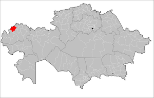
Taskala District
Taskala | |
|---|---|
District | |
| Тасқала ауданы | |
 Location of Taskala District in Kazakhstan | |
| Country | |
| Province | West Kazakhstan Province |
| Administrative center | Kamenka |
| Population (2013)[1] | |
| • Total | 17,091 |
| Time zone | UTC+5 (West) |
Taskala (Kazakh: Тасқала ауданы) is a district of West Kazakhstan Province in western Kazakhstan. The administrative center of the district is the selo of Taskala (Kamenka).[2] Population: 17,091 (2013 estimate);[1] 17,202 (2009 Census results);[3] 20,645 (1999 Census results).[3]
References
- ^ a b "Население Республики Казахстан" (in Russian). Департамент социальной и демографической статистики. Retrieved 27 December 2013.
- ^ www.geonames.de Subdivisions of Kazakhstan in local languages
- ^ a b "Население Республики Казахстан" [Population of the Republic of Kazakhstan] (in Russian). Департамент социальной и демографической статистики. Retrieved 8 December 2013.

