
Tropical Storm Debbie (1965)
 Surface weather analysis of Debbie in the northern Gulf of Mexico | |
| Meteorological history | |
|---|---|
| Formed | September 24, 1965 |
| Dissipated | September 30, 1965 |
| Tropical storm | |
| 1-minute sustained (SSHWS/NWS) | |
| Highest winds | 60 mph (95 km/h) |
| Lowest pressure | 1000 mbar (hPa); 29.53 inHg |
| Overall effects | |
| Fatalities | None reported |
| Damage | $25 million (1965 USD) |
| Areas affected | Honduras, Mexico, United States Gulf Coast |
| IBTrACS | |
Part of the 1965 Atlantic hurricane season | |
Tropical Storm Debbie of the 1965 Atlantic hurricane season broke the daily rainfall record in Mobile, Alabama, despite dissipating offshore. It developed on September 24 in the western Caribbean Sea, and moved northwestward for several days without intensifying. On September 27, Debbie turned toward the northeast in the Gulf of Mexico, and the next day briefly attained tropical storm status. However, the intrusion of cooler air imparted weakening, and the storm dissipated on September 30 just off the east coast of Louisiana. It initially threatened areas of Louisiana that sustained significant damage from Hurricane Betsy in early September, although Debbie only caused light rainfall and some flooding in the state. In southern Alabama, the storm dropped 17.2 in (440 mm) of rainfall, which resulted in significant flooding of roads and cars. Damage totaled $25 million in the Mobile, Alabama area, although there was little damage elsewhere.
Meteorological history[edit]

Tropical storm (39–73 mph, 63–118 km/h)
Category 1 (74–95 mph, 119–153 km/h)
Category 2 (96–110 mph, 154–177 km/h)
Category 3 (111–129 mph, 178–208 km/h)
Category 4 (130–156 mph, 209–251 km/h)
Category 5 (≥157 mph, ≥252 km/h)
Unknown
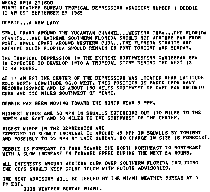
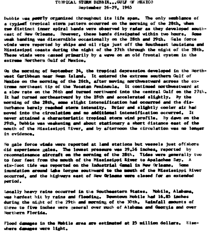
A low-pressure area developed into a weak tropical depression on September 24 off the north coast of Honduras in the western Caribbean Sea. It was initially disorganized, without a well-developed circulation.[1] On September 25, while still a tropical depression, the system was named Debbie.[2] Without intensifying further, the depression crossed the northeastern Yucatán Peninsula on September 26. The next day, the depression turned toward the north in the central Gulf of Mexico before beginning a northeast motion.[1] On September 28, Debbie intensified into a tropical storm, attaining peak winds of 50 mph (85 km/h).[3] This occurred after the storm developed two distinct spiral rainbands.[4]
As Debbie approached the northern Gulf Coast, it failed to intensify, despite warm sea surface temperatures, abundant moisture, and an anticyclone aloft. In addition, the storm never developed good outflow, partially due to stable air related to Tropical Storm Hazel in the eastern Pacific Ocean. After maintaining peak winds for about 12 hours, Debbie weakened due to cooler, drier air,[1] deteriorating to a tropical depression on September 29. That day, it turned to the northwest, passing just east of the Mississippi Delta. On September 30, the circulation of Debbie dissipated just offshore Mississippi.[3] Its remnants made landfall, accelerated northeastward, and were eventually absorbed by an extratropical cyclone.[5]
Impact[edit]

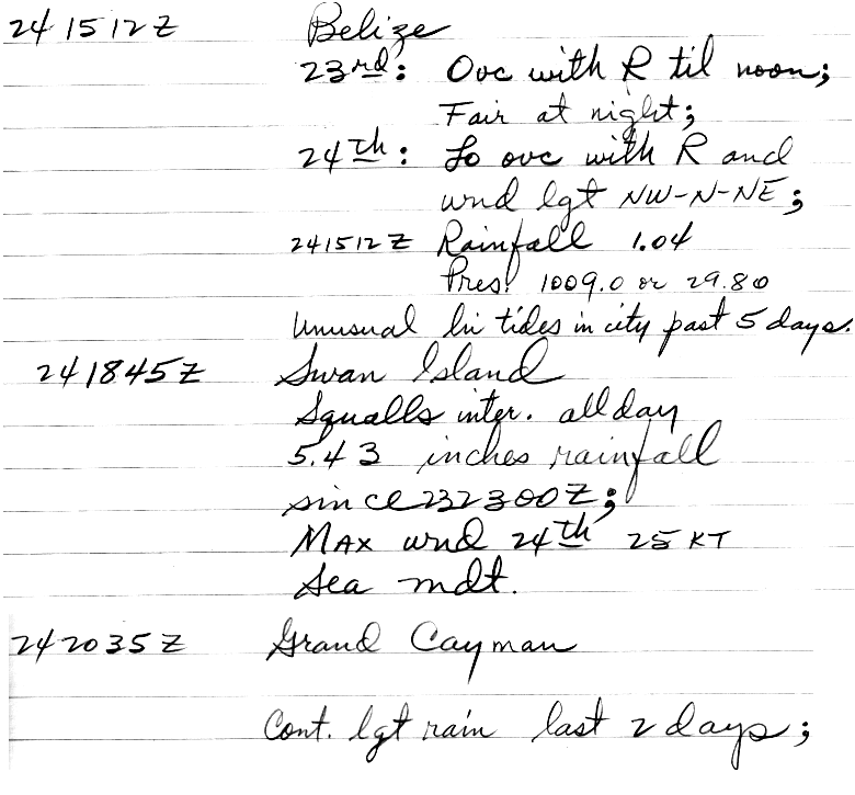
The precursor to Debbie produced heavy rainfall across the western Caribbean Sea. Swan Island off the north coast of Honduras reported 5.43 in (138 mm) in a 24-hour period.[1] In Belize City, Belize, the storm produced high tides and 1.04 in (26 mm) of rainfall. Grand Cayman reported light rains for two days.[6] The government of Cuba advised residents to restrict boating activities around the country. Similarly, the Weather Bureau issued a small craft warning for the Dry Tortugas and for the Florida Keys through Key Largo.[7]
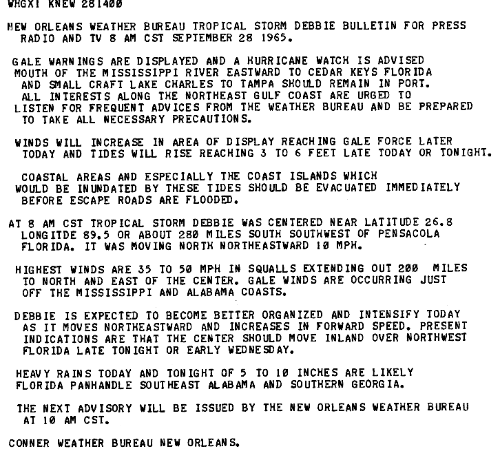
Before Debbie dissipated, local Weather Bureau offices issued a gale warning and a hurricane watch from the mouth of the Mississippi River to Cedar Key, Florida. Small boat owners throughout the region were advised to remain at port.[8] The threat of the storm prompted the evacuation of oil platforms, as well as thousands of residents in low-lying areas of St. Bernard Parish, Louisiana.[9] Along the northern Gulf Coast, no gale force winds were reported inland,[1] although oil rigs and ships off the southeast Louisiana coast reported such winds.[4] Debbie produced above-normal tides that generally ranged upwards to 4 ft (1.2 m) above normal; however, New Orleans reported a storm tide of 6 ft (1.8 m). The tides resulted in flooding along highways in southeastern Louisiana,[1] closing several roads.[9] The storm affected areas that were severely damaged by Hurricane Betsy earlier in September.[10]
Despite being a weak storm, Debbie dropped heavy rainfall along the coast,[1] peaking at 17.2 in (440 mm) in Mobile, Alabama.[5] Of the total, 15 in (380 mm) fell in 15 hours, which broke the daily rainfall record in the city.[11] The rains resulted in 6 ft (1.8 m) of flooding that closed several businesses and roads,[12] causing the worst traffic jam on record in the city. Hundreds of cars were flooded, and more than 200 people had to leave their inundated homes.[11] Damage in the city was estimated at $25 million, which was the only significant damage from the storm.[1] Rainfall extended from Louisiana to the east coast of Florida, and as far north as North Carolina.[5] In eastern Georgia near Brunswick, the storm dropped more than 9 in (230 mm) of precipitation, causing flooding in airfields and along canals.[13]
See also[edit]
References[edit]
- ^ a b c d e f g h Arnold L. Sugg (March 1966). "The Hurricane Season of 1965" (PDF). Monthly Weather Review. 94 (3): 183. Bibcode:1966MWRv...94..183S. doi:10.1175/1520-0493(1966)094<0183:THSO>2.3.CO;2. Retrieved 2011-10-19.
- ^ Arnold L. Sugg, Miami Weather Bureau (1965-09-25). "Tropical Depression Advisory Number 1 Debbie" (GIF). National Hurricane Center. Retrieved 2011-10-20.
- ^ a b "Atlantic hurricane best track (HURDAT version 2)" (Database). United States National Hurricane Center. April 5, 2023. Retrieved April 20, 2024.
 This article incorporates text from this source, which is in the public domain.
- ^ a b W. Clyde Connor (1965-10-06). "Tropical Storm Debbie... Gulf of Mexico" (GIF). National Hurricane Center. Retrieved 2011-10-20.
- ^ a b c David M. Roth (2009-04-12). "Tropical Storm Debbie - September 26-October 1, 1965". Hydrometeorological Prediction Center. Retrieved 2011-10-20.
- ^ "Summary 2" (GIF). National Hurricane Center. Retrieved 2011-10-20.
- ^ Staff writer (1965-09-26). "S. Florida Keys on Debbie Alert". Star-News. United Press International. Retrieved 2011-10-20.
- ^ Connor, New Orleans Weather Bureau (1965-09-28). "New Orleans Weather Bureau: Tropical Storm Debbie Bulletin for Press Radio and TV 8 AM CST September 28, 1965" (GIF). National Hurricane Center. Retrieved 2011-10-20.
- ^ a b Staff writer (1965-09-28). "Destination Debbie: Florida Panhandle". The Evening Independent. Associated Press. Retrieved 2011-10-20.
- ^ Staff writer (1965-09-28). "Debbie Dallying, Carol Convoluting". The Palm Beach Post. Associated Press. Retrieved 2011-10-20.
- ^ a b Staff writer (1965-10-01). "15 Inches Rain in 15 Hours for Mobile". The Morning Record. Associated Press. Retrieved 2011-10-20.
- ^ Staff writer (1965-10-01). "Debbie Floods Mobile". United Press International. Retrieved 2011-10-20.
- ^ Staff writer (1965-09-30). "Debbie Breaks Up Near Biloxi". Ocala Star-Banner. Associated Press. Retrieved 2011-10-20.
Tropical cyclones of the 1965 Atlantic hurricane season | ||
|---|---|---|
 | ||