
User:Kbh3rd/Reused
I've found some noteable re-use of a few of my images, discovered while doing further searches on topics of continued interest, so I've looked for and found others being reused, too. Sadly, most are not properly credited and are therefore copyright infringements.
- Note: Unless otherwise explicitly stated, nothing on this page grants to anyone, most particularly the infringers identified here, any exemptions to the license terms found on the description pages for these images.
Hall of Shame[edit]
Those responsible for these instances of unattributed, and hence illegal, re-use really ought to know better.
Doe Run smelter[edit]

This was used on the website of the St. Louis CBS radio affiliate KMOX with no attribution on 2012-03-20. I agree with them that it's a fine picture to illustrate the subject. Notice the stern copyright notice at the bottom of the page? They want you to respect their copyright. I sure wish that they would respect my copyright by adhering to the liberal license under which I published the picture; a simple link to the image description page is one easy way to provide the required credit. --Kbh3rdtalk 02:35, 16 April 2012 (UTC)
Decaturville crater[edit]

It was quite a surprise to find an image of my own making in a book I had just bought. Page 31 of the book Weird Missouri by James Strait (ISBN 978 1 4027 4555 3) has a shaded relief image I made of the topography of the Decaturville crater. The photo credits at the back of the book, alas, do not credit this image. The statement is made, "All photos by the author or public domain except as indicated below." Apparently the author or publisher persists in the mistaken idea that material in Wikipedia is public domain. Sigh. I actually have been contacted by two others considering using copyrighted images of mine in a book and a magazine, though as far as I know they've not actually done so yet.
Taum Sauk power plant, again[edit]

For the second time in as many months I've discovered that a commercial publisher, one who is presumably very jealous of their own copyrights, has misappropropriated the copyright I own on one of my images. This time it is the the St. Louis Post-Dispatch operation of Lee Enterprises using this picture of the Taum Sauk power plant generators in an article titled More trouble for Ameren Missouri's Taum Sauk hydroelectric plant. They happily use my property without adhering to the simple and generous terms of either of the default licenses, nor asking for other terms if the default licenses don't suit them. This same image is noted below as being found on a different company's website some time ago.
- Update: I sent a short email to the author of that story, simply stating that I own its copyright and asking who's responsible for its use. My image has been replaced by a less relevant picture by a Post photographer, but I received no reply. "Picture? What picture?" --Kbh3rdtalk 16:21, 8 January 2012 (UTC)
Others[edit]
Taum Sauk upper reservoir[edit]

Surprise! I saw one of my images when watching one of my favorite YouTube channels, Technology Connections. Host and creator Alex Watson used this image of the upper Taum Sauk reservoir when discussing energy storage. Best of all, it's properly credited. It's at the 4:10 mark of the video titled "Batteries aren't the only way to store energy. Here's another." (Wikipedia doesn't allow links to YouTube, it seems.) Spoiler, pumped storage is not the energy storage option promoted by the video.
Taum Sauk & St. Francois Mountains[edit]
-
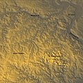 An early amateurish effort; a later version is much better. Use: FERC
 -
 Perspective 3-D topo map of the Taum Sauk plant; Use: FERC


The Federal Energy Regulatory Commission staff report on the Taum Sauk failure includes two images that I made. They're on page 18 with attribution to Wikipedia. By the terms of the posted license they ought to be attributed to my user id, but I'm not going to make a stink over it. (The better of the two was actually placed in the public domain and requires no attribution, though it would be a common courtesy.) The accompanying background information on the St. Francois Mountains adapts heavily from Wikipedia, so it includes or is based on text I've written. Again, I don't mind, but in this case it also is based on text contributed by other authors for whom I can't speak. Well, at least there is some attribution, and I don't think there's much chance of the report being redacted so many years after publishing.
Weaubleau structure[edit]

The Remote Sensing Tutorial hosted at Goddard Space Flight Center includes a map I made of the terrain of the Weaubleau-Osceola structure. It's in Section 18-5, about halfway down. No credit is given here. To the author's credit he does note in the overview that because of "a mix-up in record keeping" many of the images are not properly credited, and he invites owners to contact him for proper credit or for removal. Again, I'm not particularly bothered by this reuse -- these are hardly my best images. Let's consider this my permission to him to publish that particular image without credit. Now he only has a few hundred more to clear.
Ogalalla Aquifer[edit]


After finding those maps being re-used, I wondered if anyone has found a use for any of the few that I actually consider being fairly good. Some of my newer maps aren't half shabby, IMHO, including some that I did for the Ogallala Aquifer article. So I did a Google image search for that and quickly found two being used on an intelligent blog covering freshwater issues.[1] That content is still fresh, so I sent the proprietor what I hope he perceives to be a polite and friendly note requesting attribution per the licenses under which the maps are offered.
Answers.com has re-used[2] another map I did for the Ogallala Aquifer. That use links to its Wikipedia description page -- the first such attribution in action I've found. That may come from the fact that they've included the entire Wikipedia Aquifer article – with attribution. I guess it wouldn't be surprising to find other images of mine being used there, hopefully as properly credited.
Yellowstone caldera[edit]

This exact SVG recreation I did of an existing raster diagram of the Yellowstone caldera has been reused a few places, including one claiming that the earthquake swarms and a pending eruption there are being created by HAARP in order to scare the populace into accepting the need for drastic totalitarian measures. Or some such nonsense. I'm glad that I put this one into the public domain so that those kooks are not obliged to invoke me when reusing the image to bolster their fantasies.
Isthmus of Tehuantepec[edit]

This colorful relief map of the Isthmus of Tehuantepec is used in a number of places in either its rectangular or projected form.[3][4][5][6][7] That last link is just one of several direct copies from the associated Wikipedia article that include the image. This one correctly links back to the Wikimedia Commons page where correct attribution can be found. Many of the others don't do that. This map was made with an old program called "drawmap", which only produces rectangular unprojected latitude-longitude maps, so I wrote my own Perl program to do the mathematical transformation to an Albers equal-area conic projection. It worked, but was p-a-i-n-f-u-l-l-y slow. I've since learned to use gdalwarp which is much more capable and much faster.
Taum Sauk power plant[edit]
Agamo Corporation is using my picture of the Taum Sauk powerplant. That's the side view mirror of my old '96 Dodge Ram 2500 van in the lower right corner. This was taken with the very first digital camera I ever owned -- a pretty minimal model that was given to me as a hand-me-down by a friend.
Eads Bridge[edit]

The Eads Bridge article says that the bridge is an "iconic symbol" for St. Louis, though it has been somewhat eclipsed in that regard by the giant wicket. Apparently the St. Louis Concierge Service Association still likes the bridge, though, as my panorama is used as the banner for their site. Elite Engineering Services, LLC likes it, too, though presumably just because it's a cool bridge, what with them being located in the Kansas City area. The astute observer will notice that EES is using an earlier version of the panorama that put some curve into the bridge. That was only up for about a day before it was superceded by the current version. I don't know if they happened across it on that one day and nabbed it then, or if they made the effort to find the original and liked it better. This is one of my favorite images, and I would like to get credit for it. The color, lighting, and composition all work for this one. The only thing I don't really like about it is that bollard in the lower left corner. I used its neighbor to rest the camera on in lieu of a tripod; multi-shot panoramas work out much better if each photo is taken from exactly the same spot and orientation.
X Prize award ceremony[edit]

The X Prize Foundation themselves have used my picture of the awarding of the symbolic giant check to Paul Allen and Burt Rutan after they won the original Ansari X Prize. I'm still available if they're ever in town and forget to bring a photographer again, but I would ask them to please provide proper credit, which is lacking with this use.
San Francisquito Reservoir[edit]

This is a map I made of where the San Francisquito Reservoir, or the St. Francis Reservoir, was located prior to the catastrophic failure of the St. Francis Dam in 1928. I found the maximum pool elevation of the erstwhile reservoir and traced that elevation on a topo map of the site. This was found useful enough for inclusion in an interesting paper titled Ethical Issues from the St. Francis Dam Failure, which appears to be for a continuing education course for professional engineers. That's great. Also great is that the author provided exactly the proper credit! I wouldn't have had to put the exclamation point on the previous sentence if it wasn't such a rare exception. Kudos to the author for demonstrating proper copyright ethics.
If I had thought about it more when uploading this one, I might have put it into the public domain. It took a bit of work, and a modicum of artistic judgement was employed, but it's based on public domain maps from the USGS, to which I just added a bit of information. However, as it stands this derivative work is not public domain, and I appreciate seeing proper attribution as required by the licenses. --Kbh3rdtalk 00:48, 21 January 2012 (UTC)
Shaw Nature Reserve[edit]

I think that this picture taken at Shaw Nature Reserve is really nice, and I guess that Trip Advisor agrees. It's one of my favorites, actually. I suppose that TA has lots of user-provided content, and maybe some John Doe uploaded the picture to that site. But the caption states "Provided by management". And guess what happens when you right-click on the image there: Sample embed code pops up along with the warning that "Images must be attributed to TripAdvisor." How about the image must be attributed to its creator!
In perhaps a greater act of flattery, for either my photographic skill or for the nature reserve itself, I previously found this on the front page of the official site of an entirely unrelated arboretum in a different state. I guess it beat anything they had of their own stuff! That usage doesn't show in search results any more, however, so I guess it's no longer being used there. --Kbh3rdtalk 04:30, 10 August 2013 (UTC)