
Uyea, Unst
| Location | |
|---|---|
| OS grid reference | HU600994 |
| Physical geography | |
| Island group | Shetland |
| Area | 205 ha (0.79 sq mi) |
| Area rank | 105= [1] |
| Highest elevation | The Ward 50 m (164 ft) |
| Administration | |
| Sovereign state | United Kingdom |
| Country | Scotland |
| Council area | Shetland Islands |
| Demographics | |
| Population | 0 |
| References | [2][3][4][5] |
Uyea is an uninhabited island, lying south of Unst in Shetland, Scotland.
History
The island was inhabited as early as the Bronze Age, and a chambered cairn can still be seen.
In the 12th century, Saint Olaf's chapel overlooking Brei Wick was built.
In 1745, two girls from Uyea rowed to the small island of Haaf Gruney to milk some of the cows grazing here. Unfortunately, their return was marred by a strong storm, and eventually they found their tiny boat blown to Karmøy in south west Norway. The Uyea girls ended up marrying Karmøy men, and their descendants still live there.[3]
Jack Priest, in his evocative memoir of the isle during World War II, describes it as "a beachcomber's dream - washed as it is with a westerly Atlantic tide through Bluemull Sound, fed from the east by waters of the Norwegian basin and finally the North Sea pressing up from among the isles through the narrow channel between Yell and Fetlar and feeding Colgrave Sound on the south side of Uyea Isle."[6]
The island was the home of Sir Basil Neven-Spence, Member of Parliament (MP) for Orkney and Shetland from 1935 to 1950.
Gallery
-
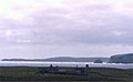 Uyea Hall
 -
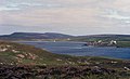 View over Uyeasound from Uyea


Footnotes
- ^ Area and population ranks: there are c. 300 islands over 20 ha in extent and 93 permanently inhabited islands were listed in the 2011 census.
- ^ National Records of Scotland (15 August 2013). "Appendix 2: Population and households on Scotland's Inhabited Islands" (PDF). Statistical Bulletin: 2011 Census: First Results on Population and Household Estimates for Scotland Release 1C (Part Two) (PDF) (Report). SG/2013/126. Retrieved 14 August 2020.
- ^ a b Haswell-Smith, Hamish (2004). The Scottish Islands. Edinburgh: Canongate. ISBN 978-1-84195-454-7.
- ^ Ordnance Survey. OS Maps Online (Map). 1:25,000. Leisure.
- ^ Anderson, Joseph (Ed.) (1893) Orkneyinga Saga. Translated by Jón A. Hjaltalin & Gilbert Goudie. Edinburgh. James Thin and Mercat Press (1990 reprint). ISBN 0-901824-25-9
- ^ Priest, Jack Island at War (1994)
External links
- "Brochs and photos from Shetland, UK" Licensed under the GNU Free Documentation License
| Inhabited islands | ||
|---|---|---|
| Other islands | ||
| Towns and villages | ||
| Points of interest | ||
60°40′N 0°54′W / 60.667°N 0.900°W
This Shetland location article is a stub. You can help Wikipedia by expanding it. |