Vändra Parish
Appearance
Vändra Parish
Vändra vald | |
|---|---|
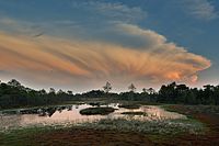
 Mõrdama bog | |
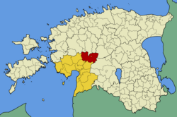
 Vändra Parish within Pärnu County. | |
| Country | Estonia |
| County | Pärnu County |
| Administrative centre | Vändra |
| Area | |
| • Total | 642 km2 (248 sq mi) |
| Population (01.12.2012[1]) | |
| • Total | 2,861 |
| • Density | 4.5/km2 (12/sq mi) |
| Website | www |
Vändra Parish was an Estonian municipality located in Pärnu County. It had a population of 2,861 (as of 1 December 2012)[1] and covered an area of 642 km².
On 27 October 2009 the neighbouring Kaisma Parish was merged with Vändra Parish.
Settlements
[edit]- Villages
Aluste - Allikõnnu - Kaansoo - Kadjaste - Kaisma - Kalmaru - Kergu - Kirikumõisa - Kobra - Kõnnu - Kose - Kullimaa - Kurgja - Leetva - Luuri - Lüüste - Mädara - Massu - Metsavere - Metsaküla - Mustaru - Oriküla - Pärnjõe - Rae - Rahkama - Rahnoja - Rätsepa - Reinumurru - Rõusa - Säästla - Samliku - Sikana - Sohlu - Suurejõe - Tagassaare - Ünnaste - Vaki - Venekuusiku - Veskisoo - Vihtra - Viluvere - Võidula - Võiera
References
[edit]- ^ a b "Külad, rahvaarv" (in Estonian). Vändra vald. Retrieved 1 January 2013.
External links
[edit]- Official website (in Estonian)


