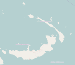
Watpi
Watpi | |
|---|---|
Village | |
| Coordinates: 4°21′S 152°41′E / 4.350°S 152.683°E | |
| Country | |
| Province | New Ireland Province |
| District | Namatanai District |
Watpi is a village on the south-west coast of New Ireland, Papua New Guinea, north of Kait. The villagers speak the Kandas language.[1] Traditionally the chief of Watpi has three wives.[2] It is located in Konoagil Rural LLG.[3]
References[edit]
- ^ Frawley, William J. (1 May 2003). International Encyclopedia of Linguistics: 4-Volume Set: 4-Volume Set. Oxford University Press. p. 2. ISBN 978-0-19-513977-8. Retrieved 31 December 2012.
- ^ Westermarck, Edward (1 April 2003). History of Human Marriage 1922. Kessinger Publishing. p. 19. ISBN 978-0-7661-4525-2. Retrieved 31 December 2012.
- ^ United Nations in Papua New Guinea (2018). "Papua New Guinea Village Coordinates Lookup". Humanitarian Data Exchange. 1.31.9.

